
Topografische Karte Austin
Interaktive Karte
Klicken Sie auf die Karte, um die Höhe anzuzeigen.
Über diese Karte
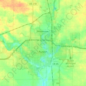
Name: Topografische Karte Austin, Höhe, Relief.
Ort: Austin, Mower County, Minnesota, 55912, United States (43.64170 -93.04923 43.71334 -92.91901)
Durchschnittliche Höhe: 374 m
Minimale Höhe: 359 m
Maximale Höhe: 393 m
According to the United States Census Bureau, the city has a total area of 11.90 square miles (30.82 km2), of which 11.79 square miles (30.54 km2) is land and 0.11 square miles (0.28 km2) is water. Its elevation is approximately 1,200 ft (370 m).
Andere topografische Karten
Klicken Sie auf eine Karte, um ihre Topografie, ihre Höhe und ihr Relief anzuzeigen.
Corning
United States > Minnesota > Mower County
Corning, Mower County, Minnesota, United States
Durchschnittliche Höhe: 389 m
Brownsdale
United States > Minnesota > Mower County
Brownsdale, Mower County, Minnesota, United States
Durchschnittliche Höhe: 391 m
Dexter
United States > Minnesota > Mower County
Dexter, Mower County, Minnesota, United States
Durchschnittliche Höhe: 427 m
Lyle
United States > Minnesota > Mower County
Lyle, Mower County, Minnesota, United States
Durchschnittliche Höhe: 363 m