
Topografische Karte Odeillo
Interaktive Karte
Klicken Sie auf die Karte, um die Höhe anzuzeigen.
Über diese Karte
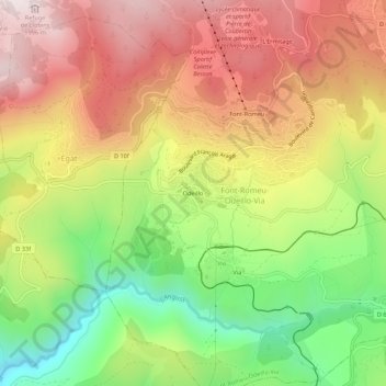
Name: Topografische Karte Odeillo, Höhe, Relief.
Durchschnittliche Höhe: 1.631 m
Minimale Höhe: 1.261 m
Maximale Höhe: 1.976 m
Andere topografische Karten
Klicken Sie auf eine Karte, um ihre Topografie, ihre Höhe und ihr Relief anzuzeigen.
Font-Romeu
France > Occitanie > Pyrénées-Orientales > Font-Romeu-Odeillo-Via
Font-Romeu, Font-Romeu-Odeillo-Via, Prades, Pyrénées-Orientales, Occitanie, France métropolitaine, 66120, France
Durchschnittliche Höhe: 1.710 m
Via
France > Occitanie > Pyrénées-Orientales > Font-Romeu-Odeillo-Via
Via, Font-Romeu-Odeillo-Via, Prades, Pyrénées-Orientales, Occitanie, France métropolitaine, 66120, France
Durchschnittliche Höhe: 1.551 m
L'Ermitage
France > Occitanie > Pyrénées-Orientales > Font-Romeu-Odeillo-Via
L'Ermitage, Font-Romeu-Odeillo-Via, Prades, Pyrénées-Orientales, Occitanie, France métropolitaine, 66120, France
Durchschnittliche Höhe: 1.785 m