
Topografische Karte Sarasota
Interaktive Karte
Klicken Sie auf die Karte, um die Höhe anzuzeigen.
Über diese Karte
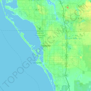
Name: Topografische Karte Sarasota, Höhe, Relief.
Ort: Sarasota, Sarasota County, Florida, 34321, United States (27.17658 -82.69085 27.49658 -82.37085)
Durchschnittliche Höhe: 6 m
Minimale Höhe: -1 m
Maximale Höhe: 36 m
Andere topografische Karten
Klicken Sie auf eine Karte, um ihre Topografie, ihre Höhe und ihr Relief anzuzeigen.
Sarasota Heights
United States > Florida > Sarasota County > Sarasota
Sarasota Heights, Sarasota, Sarasota County, Florida, 34239, United States
Durchschnittliche Höhe: 7 m
Lido Key
United States > Florida > Sarasota County > Sarasota
Lido Key, Sarasota, Sarasota County, Florida, 34230, United States
Durchschnittliche Höhe: 5 m
Southgate
United States > Florida > Sarasota County > Sarasota
Southgate, Sarasota, Sarasota County, Florida, United States
Durchschnittliche Höhe: 10 m
Fruitville
United States > Florida > Sarasota County > Sarasota
Fruitville, Sarasota, Sarasota County, Florida, United States
Durchschnittliche Höhe: 10 m