
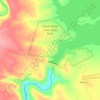
Topografische Karte Santa Rosa Lake State Park
Interaktive Karte
Klicken Sie auf die Karte, um die Höhe anzuzeigen.
Über diese Karte
Name: Topografische Karte Santa Rosa Lake State Park, Höhe, Relief.
Durchschnittliche Höhe: 1.465 m
Minimale Höhe: 1.406 m
Maximale Höhe: 1.511 m
Andere topografische Karten
Klicken Sie auf eine Karte, um ihre Topografie, ihre Höhe und ihr Relief anzuzeigen.
Tejon
United States > New Mexico > Guadalupe County
Tejon, Guadalupe County, New Mexico, United States
Durchschnittliche Höhe: 1.861 m
Santa Rosa
United States > New Mexico > Guadalupe County
Santa Rosa, Guadalupe County, New Mexico, United States
Durchschnittliche Höhe: 1.424 m
Cuervo
United States > New Mexico > Guadalupe County
Cuervo, Guadalupe County, New Mexico, United States
Durchschnittliche Höhe: 1.502 m
Vaughn
United States > New Mexico > Guadalupe County
Vaughn, Guadalupe County, New Mexico, 88353, United States
Durchschnittliche Höhe: 1.816 m