
Topografische Karte Columbus
Interaktive Karte
Klicken Sie auf die Karte, um die Höhe anzuzeigen.
Über diese Karte
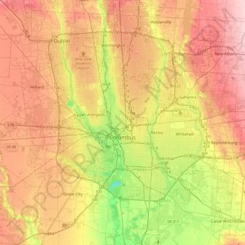
Name: Topografische Karte Columbus, Höhe, Relief.
Ort: Columbus, Franklin County, Ohio, United States (39.80869 -83.21018 40.15731 -82.77131)
Durchschnittliche Höhe: 261 m
Minimale Höhe: 169 m
Maximale Höhe: 343 m
The confluence of the Scioto and Olentangy rivers is just northwest of Downtown Columbus. Several smaller tributaries course through the Columbus metropolitan area, including Alum Creek, Big Walnut Creek and Darby Creek. Columbus is considered to have relatively flat topography thanks to a large glacier that covered most of Ohio during the Wisconsin Ice Age. However, there are sizable differences in elevation through the area, with the high point of Franklin County being 1,132 ft (345 m) above sea level near New Albany, and the low point being 670 ft (200 m) where the Scioto River leaves the county near Lockbourne.