
Topografische Karte Culebra
Interaktive Karte
Klicken Sie auf die Karte, um die Höhe anzuzeigen.
Culebra
Culebra is characterized by an irregular topography resulting in a long intricate shoreline. The island is approximately 7 by 5 miles (11 by 8 km). The coast is marked by cliffs, sandy coral beaches and mangrove forests. Inland, the tallest point on the island is Mount Resaca, with an elevation of 636 ft (193.9 m), followed by Balcón Hill, with an elevation of 545 ft (166.1 m).
Über diese Karte
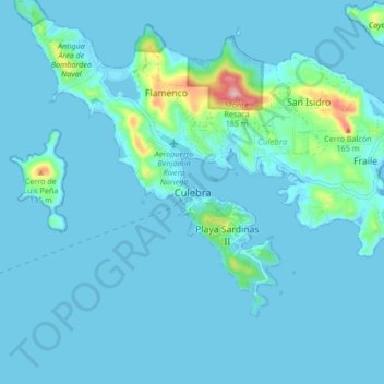
Name: Topografische Karte Culebra, Höhe, Relief.
Ort: Culebra, Puerto Rico, 00775-0969, United States (18.26305 -65.34010 18.34305 -65.26010)
Durchschnittliche Höhe: 16 m
Minimale Höhe: -3 m
Maximale Höhe: 188 m
Andere topografische Karten
Klicken Sie auf eine Karte, um ihre Topografie, ihre Höhe und ihr Relief anzuzeigen.
Isla de Culebra
United States > Puerto Rico > Culebra > Culebra
Culebra is characterized by an irregular topography resulting in a long intricate shoreline. The island is approximately 7 by 5 miles (11 by 8 km). The coast is marked by cliffs, sandy coral beaches and mangrove forests. Inland, the tallest point on the island is Mount Resaca, with an elevation of 636 feet…
Durchschnittliche Höhe: 11 m