
Topografische Karte Cedros Island
Interaktive Karte
Klicken Sie auf die Karte, um die Höhe anzuzeigen.
Über diese Karte
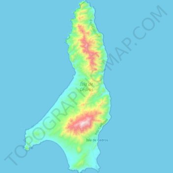
Name: Topografische Karte Cedros Island, Höhe, Relief.
Durchschnittliche Höhe: 67 m
Minimale Höhe: -3 m
Maximale Höhe: 1.178 m
Cedros Island (Isla de Cedros, "island of cedars" in Spanish) is an island in the Pacific Ocean belonging to the state of Baja California, Mexico. The dry and rocky island had a population of 1,350 in 2005 and has an area of 348 square kilometres (134 sq mi) which includes the area of several small nearby islands. Cedros Island is mountainous, reaching a maximum elevation of 1,205 metres (3,953 ft). The economy is based on commercial fishing and salt production. Cedros has a distinctive flora and the traces of some of the earliest human beings in the New World. The ocean around the island is popular with sport fishermen.
Andere topografische Karten
Klicken Sie auf eine Karte, um ihre Topografie, ihre Höhe und ihr Relief anzuzeigen.
San Miguel (Cíbolas de Mar)
Mexico > Baja California > Municipio de Ensenada > Ensenada
San Miguel (Cíbolas de Mar), Ensenada, Municipio de Ensenada, Baja California, 22760, Mexico
Durchschnittliche Höhe: 57 m
Ensenada
Mexico > Baja California > Municipio de Ensenada
Ensenada, Municipio de Ensenada, Baja California, Mexico
Durchschnittliche Höhe: 184 m