
Topografische Karte Possum Kingdom Lake
Interaktive Karte
Klicken Sie auf die Karte, um die Höhe anzuzeigen.
Über diese Karte
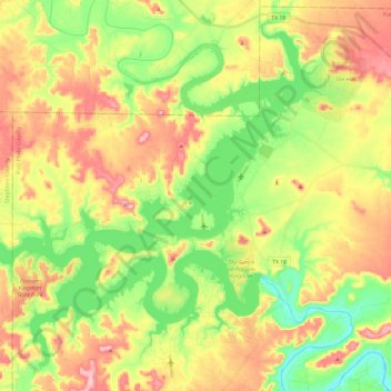
Name: Topografische Karte Possum Kingdom Lake, Höhe, Relief.
Ort: Possum Kingdom Lake, Palo Pinto County, Texas, United States (32.81952 -98.62270 33.00461 -98.38760)
Durchschnittliche Höhe: 334 m
Minimale Höhe: 261 m
Maximale Höhe: 422 m
Andere topografische Karten
Klicken Sie auf eine Karte, um ihre Topografie, ihre Höhe und ihr Relief anzuzeigen.
Mineral Wells
United States > Texas > Palo Pinto County
Mineral Wells, Palo Pinto County, Texas, United States
Durchschnittliche Höhe: 294 m
Wolters Village
United States > Texas > Palo Pinto County > Mineral Wells
Wolters Village, Mineral Wells, Palo Pinto County, Texas, 76067, United States
Durchschnittliche Höhe: 279 m
Gordon
United States > Texas > Palo Pinto County
Gordon, Palo Pinto County, Texas, United States
Durchschnittliche Höhe: 307 m
Strawn
United States > Texas > Palo Pinto County
Strawn, Palo Pinto County, Texas, United States
Durchschnittliche Höhe: 312 m
Gordon
United States > Texas > Palo Pinto County > Gordon > Gordon
Gordon, Palo Pinto County, Texas, 76453, United States
Durchschnittliche Höhe: 301 m
Graford
United States > Texas > Palo Pinto County
Graford, Palo Pinto County, Texas, United States
Durchschnittliche Höhe: 296 m