
Topografische Karte Fillmore County
Interaktive Karte
Klicken Sie auf die Karte, um die Höhe anzuzeigen.
Über diese Karte
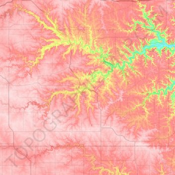
Name: Topografische Karte Fillmore County, Höhe, Relief.
Ort: Fillmore County, Minnesota, États-Unis d'Amérique (43.50038 -92.45087 43.84830 -91.73042)
Durchschnittliche Höhe: 363 m
Minimale Höhe: 216 m
Maximale Höhe: 423 m
Andere topografische Karten
Klicken Sie auf eine Karte, um ihre Topografie, ihre Höhe und ihr Relief anzuzeigen.
Roseau County
États-Unis d'Amérique > Minnesota
Roseau County, Minnesota, États-Unis d'Amérique
Durchschnittliche Höhe: 341 m
Saint Paul
États-Unis d'Amérique > Minnesota > Ramsey County
Saint Paul, Ramsey County, Minnesota, États-Unis d'Amérique
Durchschnittliche Höhe: 268 m
Kingburg Lake
États-Unis d'Amérique > Minnesota > Saint Louis County
Kingburg Lake, Saint Louis County, Minnesota, États-Unis d'Amérique
Durchschnittliche Höhe: 399 m
La Prairie
États-Unis d'Amérique > Minnesota > Itasca County
La Prairie, Itasca County, Minnesota, États-Unis d'Amérique
Durchschnittliche Höhe: 393 m
St. Joseph
États-Unis d'Amérique > Minnesota > Stearns County
St. Joseph, Stearns County, Minnesota, États-Unis d'Amérique
Durchschnittliche Höhe: 336 m
Lauren
États-Unis d'Amérique > Minnesota > Lake County
Lauren, Lake County, Minnesota, États-Unis d'Amérique
Durchschnittliche Höhe: 466 m
Maple Grove
États-Unis d'Amérique > Minnesota > Hennepin County
Maple Grove, Hennepin County, Minnesota, États-Unis d'Amérique
Durchschnittliche Höhe: 278 m
Greely
États-Unis d'Amérique > Minnesota > Pine County
Greely, Pine County, Minnesota, États-Unis d'Amérique
Durchschnittliche Höhe: 292 m
Lakefield
États-Unis d'Amérique > Minnesota > Jackson County > Lakefield
Lakefield, Jackson County, Minnesota, États-Unis d'Amérique
Durchschnittliche Höhe: 450 m
Pearl Lake
États-Unis d'Amérique > Minnesota
Pearl Lake, Lake County, Minnesota, États-Unis d'Amérique
Durchschnittliche Höhe: 521 m
Pennington County
États-Unis d'Amérique > Minnesota
Pennington County, Minnesota, États-Unis d'Amérique
Durchschnittliche Höhe: 338 m
McGrath
États-Unis d'Amérique > Minnesota > McGrath
McGrath, Aitkin County, Minnesota, États-Unis d'Amérique
Durchschnittliche Höhe: 379 m
Fire Lake
États-Unis d'Amérique > Minnesota
Fire Lake, Kekekabic Trail, Lake County, Minnesota, États-Unis d'Amérique
Durchschnittliche Höhe: 471 m
Whiteface
États-Unis d'Amérique > Minnesota > Whiteface
Whiteface, Saint Louis County, Minnesota, États-Unis d'Amérique
Durchschnittliche Höhe: 418 m
Cathedral Hill Park
États-Unis d'Amérique > Minnesota > St. Paul
Cathedral Hill Park, St. Paul, Ramsey County, Minnesota, États-Unis d'Amérique
Durchschnittliche Höhe: 252 m
Lake Itasca
États-Unis d'Amérique > Minnesota > Lake Itasca
Lake Itasca, Clearwater County, Minnesota, 56480, États-Unis d'Amérique
Durchschnittliche Höhe: 460 m
Opstead
États-Unis d'Amérique > Minnesota > Opstead
Opstead, Mille Lacs County, Minnesota, États-Unis d'Amérique
Durchschnittliche Höhe: 396 m
Deering Island
États-Unis d'Amérique > Minnesota > Orono
Deering Island, Orono, Hennepin County, Minnesota, États-Unis d'Amérique
Durchschnittliche Höhe: 286 m
International Falls
États-Unis d'Amérique > Minnesota > International Falls
International Falls, Koochiching County, Minnesota, États-Unis d'Amérique
Durchschnittliche Höhe: 347 m
Kettle River
États-Unis d'Amérique > Minnesota
Kettle River, Carlton County, Minnesota, 55757, États-Unis d'Amérique
Durchschnittliche Höhe: 367 m
Hennepin County
États-Unis d'Amérique > Minnesota
Hennepin County, Minnesota, États-Unis d'Amérique
Durchschnittliche Höhe: 280 m
Manitou
États-Unis d'Amérique > Minnesota > Manitou
Manitou, Koochiching County, Minnesota, États-Unis d'Amérique
Durchschnittliche Höhe: 341 m
Red Lake County
États-Unis d'Amérique > Minnesota
Red Lake County, Minnesota, États-Unis d'Amérique
Durchschnittliche Höhe: 341 m
Nansen
États-Unis d'Amérique > Minnesota > Nansen
Nansen, Goodhue County, Minnesota, États-Unis d'Amérique
Durchschnittliche Höhe: 335 m
Source Lake
États-Unis d'Amérique > Minnesota > Whyte
Source Lake, Whyte Road, Whyte, Lake County, Minnesota, États-Unis d'Amérique
Durchschnittliche Höhe: 579 m
Ramsey County
États-Unis d'Amérique > Minnesota
Ramsey County, Minnesota, États-Unis d'Amérique
Durchschnittliche Höhe: 279 m
Astray Lake
États-Unis d'Amérique > Minnesota
Astray Lake, Portage, Lake County, Minnesota, États-Unis d'Amérique
Durchschnittliche Höhe: 446 m