
Topografische Karte Kennesaw Mountain
Interaktive Karte
Klicken Sie auf die Karte, um die Höhe anzuzeigen.
Über diese Karte
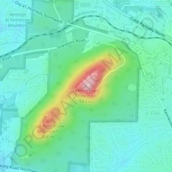
Name: Topografische Karte Kennesaw Mountain, Höhe, Relief.
Durchschnittliche Höhe: 360 m
Minimale Höhe: 310 m
Maximale Höhe: 532 m
Kennesaw Mountain is a mountain between Marietta and Kennesaw, Georgia in the United States with a summit elevation of 1,808 feet (551 m). It is the highest point in the core (urban and suburban) metro Atlanta area, and fifth after further-north exurban counties are considered. The local terrain averages roughly 1,000 feet (300 m) AMSL.
Andere topografische Karten
Klicken Sie auf eine Karte, um ihre Topografie, ihre Höhe und ihr Relief anzuzeigen.
Vinings
United States > Georgia > Cobb County
Vinings, Cobb County, Georgia, 30339, United States
Durchschnittliche Höhe: 281 m
Kennesaw
United States > Georgia > Cobb County
Kennesaw, Cobb County, Georgia, 30144, United States
Durchschnittliche Höhe: 317 m
North Georgia Fairgrounds Lake Dam
United States > Georgia > Cobb County
North Georgia Fairgrounds Lake Dam, Cobb County, Georgia, 30008, United States
Durchschnittliche Höhe: 313 m
Lost Mountain Park
United States > Georgia > Cobb County
Lost Mountain Park, Cobb County, Georgia, United States
Durchschnittliche Höhe: 343 m
Austell
United States > Georgia > Cobb County
Austell, Cobb County, Georgia, United States
Durchschnittliche Höhe: 289 m
Acworth
United States > Georgia > Cobb County
Acworth, Cobb County, Georgia, United States
Durchschnittliche Höhe: 281 m
Clarkdale
United States > Georgia > Cobb County
Clarkdale, Cobb County, Georgia, 30111, United States
Durchschnittliche Höhe: 281 m
Marietta
United States > Georgia > Cobb County
Marietta, Cobb County, Georgia, United States
Durchschnittliche Höhe: 323 m
Smyrna
United States > Georgia > Cobb County
Smyrna, Cobb County, Georgia, United States
Durchschnittliche Höhe: 289 m
Fair Oaks
United States > Georgia > Cobb County
Fair Oaks, Cobb County, Georgia, United States
Durchschnittliche Höhe: 329 m
Powder Springs
United States > Georgia > Cobb County
Powder Springs, Cobb County, Georgia, United States
Durchschnittliche Höhe: 291 m
Mableton
United States > Georgia > Cobb County
Mableton, Cobb County, Georgia, 30126, United States
Durchschnittliche Höhe: 298 m
Austell
United States > Georgia > Cobb County > Austell
Austell, Cobb County, Georgia, 30001, United States
Durchschnittliche Höhe: 283 m
Kennesaw
United States > Georgia > Cobb County > Kennesaw
Kennesaw, Cobb County, Georgia, 30144, United States
Durchschnittliche Höhe: 318 m
Viking Quarry Lake
United States > Georgia > Cobb County
Viking Quarry Lake, Cobb County, Georgia, United States
Durchschnittliche Höhe: 303 m
Lost Mountain
United States > Georgia > Cobb County
Lost Mountain, Cobb County, Georgia, United States
Durchschnittliche Höhe: 340 m
Marietta
United States > Georgia > Cobb County > Marietta
Marietta, Cobb County, Georgia, 30090, United States
Durchschnittliche Höhe: 302 m
Acworth
United States > Georgia > Cobb County > Acworth
Acworth, Cobb County, Georgia, 30101, United States
Durchschnittliche Höhe: 280 m
Sweetwater Creek
United States > Georgia > Cobb County > Douglasville
Sweetwater Creek, Douglasville, Cobb County, Georgia, 30122, United States
Durchschnittliche Höhe: 287 m