
Topografische Karte Marshall Lake
Interaktive Karte
Klicken Sie auf die Karte, um die Höhe anzuzeigen.
Über diese Karte
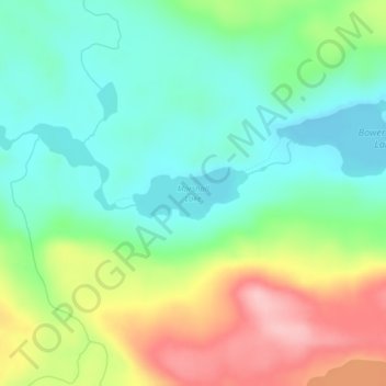
Name: Topografische Karte Marshall Lake, Höhe, Relief.
Durchschnittliche Höhe: 556 m
Minimale Höhe: 496 m
Maximale Höhe: 665 m
Andere topografische Karten
Klicken Sie auf eine Karte, um ihre Topografie, ihre Höhe und ihr Relief anzuzeigen.
Ernest Lake
United States > Minnesota > Cook County
Ernest Lake, West Cook, Cook County, Minnesota, United States
Durchschnittliche Höhe: 505 m
Sea Gull Lake
United States > Minnesota > Cook County
Sea Gull Lake, West Cook, Cook County, Minnesota, United States
Durchschnittliche Höhe: 460 m
Cream Lake
United States > Minnesota > Cook County
Cream Lake, West Cook, Cook County, Minnesota, United States
Durchschnittliche Höhe: 574 m
George Lake
United States > Minnesota > Cook County
George Lake, West Cook, Cook County, Minnesota, United States
Durchschnittliche Höhe: 551 m
Bull Lake
United States > Minnesota > Cook County
Bull Lake, West Cook, Cook County, Minnesota, United States
Durchschnittliche Höhe: 571 m
Jimmy Lake
United States > Minnesota > Cook County
Jimmy Lake, West Cook, Cook County, Minnesota, United States
Durchschnittliche Höhe: 489 m
Benson Lake
United States > Minnesota > Cook County
Benson Lake, East Cook, Cook County, Minnesota, United States
Durchschnittliche Höhe: 505 m
Tofte
United States > Minnesota > Cook County > Tofte
Tofte, Cook County, Minnesota, 55613, United States
Durchschnittliche Höhe: 223 m
Kingfisher Lake
United States > Minnesota > Cook County
Kingfisher Lake, Cook County, Minnesota, United States
Durchschnittliche Höhe: 464 m
Smoke Lake
United States > Minnesota > Cook County
Smoke Lake, Cook County, Minnesota, United States
Durchschnittliche Höhe: 557 m
Axe Lake
United States > Minnesota > Cook County
Axe Lake, Cook County, Minnesota, United States
Durchschnittliche Höhe: 565 m
Grand Marais
United States > Minnesota > Cook County
Grand Marais, Cook County, Minnesota, United States
Durchschnittliche Höhe: 280 m