
Topografische Karte Mason Island
Interaktive Karte
Klicken Sie auf die Karte, um die Höhe anzuzeigen.
Über diese Karte
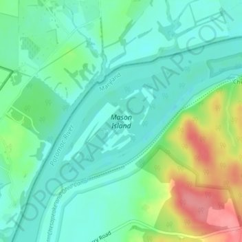
Name: Topografische Karte Mason Island, Höhe, Relief.
Ort: Mason Island, Montgomery County, Maryland, United States (39.16935 -77.51496 39.18294 -77.49245)
Durchschnittliche Höhe: 78 m
Minimale Höhe: 53 m
Maximale Höhe: 136 m
Andere topografische Karten
Klicken Sie auf eine Karte, um ihre Topografie, ihre Höhe und ihr Relief anzuzeigen.
Fairland
United States > Maryland > Montgomery County
Fairland, Montgomery County, Maryland, United States
Durchschnittliche Höhe: 111 m
Germantown
United States > Maryland > Montgomery County
Germantown, Montgomery County, Maryland, 20874, United States
Durchschnittliche Höhe: 136 m
Derwood
United States > Maryland > Montgomery County
Derwood, Montgomery County, Maryland, 20855, United States
Durchschnittliche Höhe: 133 m
Randolph Hills
United States > Maryland > Montgomery County > North Bethesda
Randolph Hills, North Bethesda, Montgomery County, Maryland, 20896, United States
Durchschnittliche Höhe: 98 m
White Oak
United States > Maryland > Montgomery County > White Oak
White Oak, Montgomery County, Maryland, 20993, United States
Durchschnittliche Höhe: 101 m
Gaithersburg
United States > Maryland > Montgomery County
Gaithersburg, Montgomery County, Maryland, United States
Durchschnittliche Höhe: 137 m
Burnt Mills Village
United States > Maryland > Montgomery County > Burnt Mills
Burnt Mills Village, Burnt Mills, Montgomery County, Maryland, 20901, United States
Durchschnittliche Höhe: 104 m
Seneca Park
United States > Maryland > Montgomery County > Montgomery Village
Seneca Park, Montgomery Village, Montgomery County, Maryland, 20876, United States
Durchschnittliche Höhe: 124 m
Hickory Ridge
United States > Maryland > Montgomery County > Damascus
Hickory Ridge, Damascus, Montgomery County, Maryland, 20872, United States
Durchschnittliche Höhe: 196 m
Lock 22: Pennyfield Lock
United States > Maryland > Montgomery County > Travilah
Lock 22: Pennyfield Lock, Estates at Rivers Edge, Travilah, Montgomery County, Maryland, United States
Durchschnittliche Höhe: 73 m
Bethesda
United States > Maryland > Montgomery County
Bethesda, Montgomery County, Maryland, United States
Durchschnittliche Höhe: 81 m
Potomac
United States > Maryland > Montgomery County > Potomac
Potomac, Montgomery County, Maryland, 20854, United States
Durchschnittliche Höhe: 86 m
North Bethesda
United States > Maryland > Montgomery County > North Bethesda
North Bethesda, Montgomery County, Maryland, United States
Durchschnittliche Höhe: 98 m
Burtonsville
United States > Maryland > Montgomery County > Burtonsville
Burtonsville, Montgomery County, Maryland, 20866, United States
Durchschnittliche Höhe: 119 m