
Spenden
Rüste dich für dein nächstes Abenteuer:
Als Amazon-Partner verdient diese Website an qualifizierten Käufen, ohne zusätzliche Kosten für Sie.
Topografische Karte Sheerness
Klicken Sie auf die Karte, um die Höhe anzuzeigen.
Spenden
Rüste dich für dein nächstes Abenteuer:
Als Amazon-Partner verdient diese Website an qualifizierten Käufen, ohne zusätzliche Kosten für Sie.
Über diese Karte
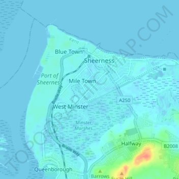
Name: Topografische Karte Sheerness, Höhe, Relief.
Ort: Sheerness, Borough of Swale, Kent, England, United Kingdom (51.41745 0.72902 51.44914 0.79273)
Durchschnittliche Höhe: 3 m
Minimale Höhe: -5 m
Maximale Höhe: 40 m
Spenden
Rüste dich für dein nächstes Abenteuer:
Als Amazon-Partner verdient diese Website an qualifizierten Käufen, ohne zusätzliche Kosten für Sie.
Andere topografische Karten
Klicken Sie auf eine Karte, um ihre Topografie, ihre Höhe und ihr Relief anzuzeigen.
Spenden
Rüste dich für dein nächstes Abenteuer:
Als Amazon-Partner verdient diese Website an qualifizierten Käufen, ohne zusätzliche Kosten für Sie.
Berryfield
United Kingdom > England > Kent > Borough of Swale > Eastchurch
Durchschnittliche Höhe: 22 m
Lower Hartlip
United Kingdom > England > Kent > Borough of Swale > Hartlip
Durchschnittliche Höhe: 55 m
Spenden
Rüste dich für dein nächstes Abenteuer:
Als Amazon-Partner verdient diese Website an qualifizierten Käufen, ohne zusätzliche Kosten für Sie.
Faversham Creek
United Kingdom > England > Kent > Borough of Swale > Faversham > Oare
Durchschnittliche Höhe: 11 m
Great Norwood
United Kingdom > England > Kent > Borough of Swale > Bobbing
Durchschnittliche Höhe: 27 m
Spenden
Rüste dich für dein nächstes Abenteuer:
Als Amazon-Partner verdient diese Website an qualifizierten Käufen, ohne zusätzliche Kosten für Sie.
Hickmans Green
United Kingdom > England > Kent > Borough of Swale > Boughton Street
Durchschnittliche Höhe: 63 m
Oare Creek
United Kingdom > England > Kent > Borough of Swale > Faversham > Oare
Durchschnittliche Höhe: 6 m
Spenden
Rüste dich für dein nächstes Abenteuer:
Als Amazon-Partner verdient diese Website an qualifizierten Käufen, ohne zusätzliche Kosten für Sie.
Spenden
Rüste dich für dein nächstes Abenteuer:
Als Amazon-Partner verdient diese Website an qualifizierten Käufen, ohne zusätzliche Kosten für Sie.
Faversham Creek
United Kingdom > England > Kent > Borough of Swale > Faversham > Oare
Durchschnittliche Höhe: 8 m
Spenden
Rüste dich für dein nächstes Abenteuer:
Als Amazon-Partner verdient diese Website an qualifizierten Käufen, ohne zusätzliche Kosten für Sie.
Lewson Street
United Kingdom > England > Kent > Borough of Swale > Norton
Durchschnittliche Höhe: 36 m
Rodmersham Green
United Kingdom > England > Kent > Borough of Swale > Rodmersham Green
Durchschnittliche Höhe: 48 m
Whitehill
United Kingdom > England > Kent > Borough of Swale > Painter's Forstal
Durchschnittliche Höhe: 45 m
Spenden
Rüste dich für dein nächstes Abenteuer:
Als Amazon-Partner verdient diese Website an qualifizierten Käufen, ohne zusätzliche Kosten für Sie.
Spenden
Rüste dich für dein nächstes Abenteuer:
Als Amazon-Partner verdient diese Website an qualifizierten Käufen, ohne zusätzliche Kosten für Sie.
Berryfield
United Kingdom > England > Kent > Borough of Swale > Eastchurch
Durchschnittliche Höhe: 22 m
Spenden
Rüste dich für dein nächstes Abenteuer:
Als Amazon-Partner verdient diese Website an qualifizierten Käufen, ohne zusätzliche Kosten für Sie.