
Spenden
Rüste dich für dein nächstes Abenteuer:
Als Amazon-Partner verdient diese Website an qualifizierten Käufen, ohne zusätzliche Kosten für Sie.
Topografische Karte Isabela
Klicken Sie auf die Karte, um die Höhe anzuzeigen.
Spenden
Rüste dich für dein nächstes Abenteuer:
Als Amazon-Partner verdient diese Website an qualifizierten Käufen, ohne zusätzliche Kosten für Sie.
Isabela
The province is divided into three physiographic areas. The eastern area, straddled by the Sierra Madre mountain range, is rugged and thickly forested. A substantial portion is uncharted. These unexplored hinterlands are home to a rich variety of flora and fauna, and some are under government reservations. It is home to one of the world's largest remaining low-altitude rainforests, with numerous unknown endemic species of flora and fauna and biological diversity in the protected area known as the Northern Sierra Madre Natural Park. Isabela has 600,000 hectares (1,500,000 acres) of Cagayan Valley’s 900,000 hectares (2,200,000 acres) of forest cover.
Spenden
Rüste dich für dein nächstes Abenteuer:
Als Amazon-Partner verdient diese Website an qualifizierten Käufen, ohne zusätzliche Kosten für Sie.
Über diese Karte
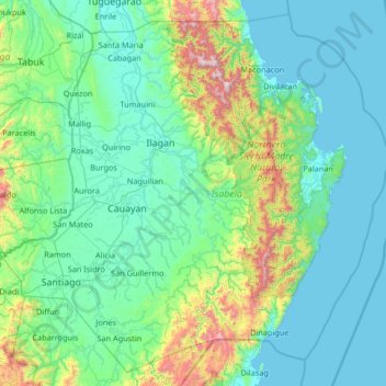
Name: Topografische Karte Isabela, Höhe, Relief.
Ort: Isabela, Cagayan Valley, Philippines (16.39443 121.33589 17.56891 122.66939)
Durchschnittliche Höhe: 227 m
Minimale Höhe: -1 m
Maximale Höhe: 1.796 m
Spenden
Rüste dich für dein nächstes Abenteuer:
Als Amazon-Partner verdient diese Website an qualifizierten Käufen, ohne zusätzliche Kosten für Sie.
Andere topografische Karten
Klicken Sie auf eine Karte, um ihre Topografie, ihre Höhe und ihr Relief anzuzeigen.
Spenden
Rüste dich für dein nächstes Abenteuer:
Als Amazon-Partner verdient diese Website an qualifizierten Käufen, ohne zusätzliche Kosten für Sie.
Spenden
Rüste dich für dein nächstes Abenteuer:
Als Amazon-Partner verdient diese Website an qualifizierten Käufen, ohne zusätzliche Kosten für Sie.
Baguio
In 1903, Filipinos, Japanese and Chinese workers were hired to build Kennon Road, the first road directly connecting Baguio with the lowlands of La Union and Pangasinan. Before this, the only road to Benguet was Naguilian Road, and it was largely a horse trail at higher elevations. Camp John Hay was…
Durchschnittliche Höhe: 881 m
Spenden
Rüste dich für dein nächstes Abenteuer:
Als Amazon-Partner verdient diese Website an qualifizierten Käufen, ohne zusätzliche Kosten für Sie.
Quezon City
Founded as a pueblo by Saint Pedro Bautista in 1590, San Francisco del Monte may be considered Quezon City's oldest district. The original land area of the old town of San Francisco del Monte was approximately2.5 square kilometres (1.0 sq mi) and covered parts of what is currently known as Project 7 and 8 and…
Durchschnittliche Höhe: 57 m
Spenden
Rüste dich für dein nächstes Abenteuer:
Als Amazon-Partner verdient diese Website an qualifizierten Käufen, ohne zusätzliche Kosten für Sie.
Trece Martires
The city of Trece Martires is characterised with ground elevation ranging from 30m to nearly 400m. Its ground slope ranges from 0.5 to 2%.
Durchschnittliche Höhe: 150 m
Spenden
Rüste dich für dein nächstes Abenteuer:
Als Amazon-Partner verdient diese Website an qualifizierten Käufen, ohne zusätzliche Kosten für Sie.
Valenzuela
The highest elevation point is 38 meters (125 ft) above sea level. Having a surface gradient of 0.55% and a gentle slope, hilly landscape is located in the industrial section of the city in Canumay. The average elevation point is 2 meters (6.6 ft) above sea level.
Durchschnittliche Höhe: 24 m
Spenden
Rüste dich für dein nächstes Abenteuer:
Als Amazon-Partner verdient diese Website an qualifizierten Käufen, ohne zusätzliche Kosten für Sie.
Tagaytay
The southern and eastern portions of Tagaytay are covered by hills and mountains which is generally forests, pine trees and open grasslands. The city lies along Tagaytay Ridge, a ridge stretching about 32 kilometres (20 mi) from Mount Batulao in the west to Mount Sungay in the east with elevations averaging…
Durchschnittliche Höhe: 229 m
Bacolod
Bacólod (English: Bacolod), is derived from bakólod (Old Spelling: bacólod), the Old Hiligaynon (Old Ilonggo) (Old Spelling: Ylongo and Ilongo) word for a "hill, turtle, mound, rise, hillock, down, any small eminence or elevation", since the resettlement was founded on a stony, hilly area, now the barangay…
Durchschnittliche Höhe: 49 m
Spenden
Rüste dich für dein nächstes Abenteuer:
Als Amazon-Partner verdient diese Website an qualifizierten Käufen, ohne zusätzliche Kosten für Sie.
Mandaluyong
Another claims that the Spaniards named the place based on the report of a navigator named Acapulco, who saw the rolling hills frequently being lashed at by daluyong (“big waves from the sea”). This seems to confirm traditional pre-Hispanic stories that giant waves from the sea would meet the adjoining…
Durchschnittliche Höhe: 33 m
Spenden
Rüste dich für dein nächstes Abenteuer:
Als Amazon-Partner verdient diese Website an qualifizierten Käufen, ohne zusätzliche Kosten für Sie.
Indang
Philippines > Cavite > Indang
The topography of Indang is characterised by gently sloping or rolling terrain. Almost 40.36% of its total land area is within the slope grade of 3-8%, while 2,135 hectares is within the slope range of 8-15% which is characterised by undulating or sloping terrain.
Durchschnittliche Höhe: 298 m
Spenden
Rüste dich für dein nächstes Abenteuer:
Als Amazon-Partner verdient diese Website an qualifizierten Käufen, ohne zusätzliche Kosten für Sie.
Spenden
Rüste dich für dein nächstes Abenteuer:
Als Amazon-Partner verdient diese Website an qualifizierten Käufen, ohne zusätzliche Kosten für Sie.
Marawi
Marawi is located upon the shores of Lake Lanao.[6] It is primarily inhabited by the Maranao people. The city is also called the "summer capital of the south" due to its higher elevation and cooler climate,[7] a nickname it shares with Malaybalay.[8][better source needed]
Durchschnittliche Höhe: 707 m
Malolos
Malolos is relatively flat of about 0.81% to a gently sloping of 2.17%. The slope of the land descends towards west, southwest to southern direction. The highest land elevation is at about 6.0 meters above sea level while the lowest is only half a meter below sea level. A network of natural waterways and…
Durchschnittliche Höhe: 6 m
Spenden
Rüste dich für dein nächstes Abenteuer:
Als Amazon-Partner verdient diese Website an qualifizierten Käufen, ohne zusätzliche Kosten für Sie.
Dasmariñas
Dasmariñas is partly lowland and partly hilly. The Poblacion itself is elevated. From an elevation of 80 meters (260 ft) at the Poblacion, the land rises to 250 meters (820 ft) towards Silang. Generally, land near rivers and creeks are rugged. Dasmariñas is outside the typhoon belt and has no fault line…
Durchschnittliche Höhe: 97 m
Spenden
Rüste dich für dein nächstes Abenteuer:
Als Amazon-Partner verdient diese Website an qualifizierten Käufen, ohne zusätzliche Kosten für Sie.
Spenden
Rüste dich für dein nächstes Abenteuer:
Als Amazon-Partner verdient diese Website an qualifizierten Käufen, ohne zusätzliche Kosten für Sie.
Spenden
Rüste dich für dein nächstes Abenteuer:
Als Amazon-Partner verdient diese Website an qualifizierten Käufen, ohne zusätzliche Kosten für Sie.
Daraga
67.3% of the total municipal land area has a predominantly low elevation of up to 100 metres (330 ft). The surface terrain is generally characterized by combination of level to nearly level areas, gentle to undulating areas and undulating to rolling areas.
Durchschnittliche Höhe: 76 m
Tagum
One of the significant accomplishments of the officialdom of Tagum during the 1990s was its elevation from a second to the first-class municipality. This opened a gateway to increase its financial resources through the Internal Revenue Allocation (IRA) from the national government and local revenues. This was…
Durchschnittliche Höhe: 103 m
Spenden
Rüste dich für dein nächstes Abenteuer:
Als Amazon-Partner verdient diese Website an qualifizierten Käufen, ohne zusätzliche Kosten für Sie.
Spenden
Rüste dich für dein nächstes Abenteuer:
Als Amazon-Partner verdient diese Website an qualifizierten Käufen, ohne zusätzliche Kosten für Sie.
San Juan
"San Juan" is a contraction of the city's traditional name of "San Juan del Monte" (lit. 'Saint John of the Mountain'). As with numerous other places in the Philippines, the name combines a patron saint and a toponym; in this case Saint John the Baptist with the locale's hilly terrain and relatively higher…
Durchschnittliche Höhe: 35 m
Spenden
Rüste dich für dein nächstes Abenteuer:
Als Amazon-Partner verdient diese Website an qualifizierten Käufen, ohne zusätzliche Kosten für Sie.
Spenden
Rüste dich für dein nächstes Abenteuer:
Als Amazon-Partner verdient diese Website an qualifizierten Käufen, ohne zusätzliche Kosten für Sie.
Spenden
Rüste dich für dein nächstes Abenteuer:
Als Amazon-Partner verdient diese Website an qualifizierten Käufen, ohne zusätzliche Kosten für Sie.
Spenden
Rüste dich für dein nächstes Abenteuer:
Als Amazon-Partner verdient diese Website an qualifizierten Käufen, ohne zusätzliche Kosten für Sie.
Spenden
Rüste dich für dein nächstes Abenteuer:
Als Amazon-Partner verdient diese Website an qualifizierten Käufen, ohne zusätzliche Kosten für Sie.
Spenden
Rüste dich für dein nächstes Abenteuer:
Als Amazon-Partner verdient diese Website an qualifizierten Käufen, ohne zusätzliche Kosten für Sie.
Spenden
Rüste dich für dein nächstes Abenteuer:
Als Amazon-Partner verdient diese Website an qualifizierten Käufen, ohne zusätzliche Kosten für Sie.
Spenden
Rüste dich für dein nächstes Abenteuer:
Als Amazon-Partner verdient diese Website an qualifizierten Käufen, ohne zusätzliche Kosten für Sie.
Spenden
Rüste dich für dein nächstes Abenteuer:
Als Amazon-Partner verdient diese Website an qualifizierten Käufen, ohne zusätzliche Kosten für Sie.