
Spenden
Rüste dich für dein nächstes Abenteuer:
Als Amazon-Partner verdient diese Website an qualifizierten Käufen, ohne zusätzliche Kosten für Sie.
Topografische Karte Table Top Rock
Klicken Sie auf die Karte, um die Höhe anzuzeigen.
Spenden
Rüste dich für dein nächstes Abenteuer:
Als Amazon-Partner verdient diese Website an qualifizierten Käufen, ohne zusätzliche Kosten für Sie.
Über diese Karte
Name: Topografische Karte Table Top Rock, Höhe, Relief.
Durchschnittliche Höhe: 1.714 m
Minimale Höhe: 1.672 m
Maximale Höhe: 1.922 m
Spenden
Rüste dich für dein nächstes Abenteuer:
Als Amazon-Partner verdient diese Website an qualifizierten Käufen, ohne zusätzliche Kosten für Sie.
Andere topografische Karten
Klicken Sie auf eine Karte, um ihre Topografie, ihre Höhe und ihr Relief anzuzeigen.
Maligne Lake
Canada > Alberta > Improvement District No. 12
Wildlife is surprisingly abundant along this high altitude oligotrophic lake. Grizzly bear, black bear, mule deer, caribou, wolves, moose, and mountain sheep are some of the larger mammals that frequent the lake area during the summer season. Bald eagles, golden eagles and osprey also frequent the area and…
Durchschnittliche Höhe: 2.125 m
Spenden
Rüste dich für dein nächstes Abenteuer:
Als Amazon-Partner verdient diese Website an qualifizierten Käufen, ohne zusätzliche Kosten für Sie.
Lawrence Glacier
Canada > Alberta > Improvement District No. 12 > Area A (Kicking Horse/Kinbasket Lake)
Durchschnittliche Höhe: 2.619 m
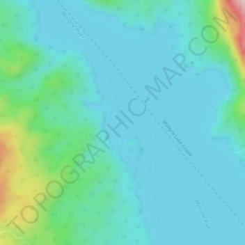
Maligne Lake
Canada > Alberta > Improvement District No. 12
Wildlife is surprisingly abundant along this high altitude oligotrophic lake. Grizzly bear, black bear, mule deer, caribou, wolves, moose, and mountain sheep are some of the larger mammals that frequent the lake area during the summer season. Bald eagles, golden eagles and osprey also frequent the area and…
Durchschnittliche Höhe: 2.125 m
Spenden
Rüste dich für dein nächstes Abenteuer:
Als Amazon-Partner verdient diese Website an qualifizierten Käufen, ohne zusätzliche Kosten für Sie.