
Topografische Karte Greater Hyderabad Municipal Corporation South Zone
Interaktive Karte
Klicken Sie auf die Karte, um die Höhe anzuzeigen.
Über diese Karte
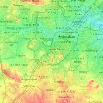
Name: Topografische Karte Greater Hyderabad Municipal Corporation South Zone, Höhe, Relief.
Durchschnittliche Höhe: 535 m
Minimale Höhe: 471 m
Maximale Höhe: 649 m
Andere topografische Karten
Klicken Sie auf eine Karte, um ihre Topografie, ihre Höhe und ihr Relief anzuzeigen.
Ward 4 Meerpet H.B Colony
Ward 4 Meerpet H.B Colony, Hyderabad, Uppal mandal, Medchal–Malkajgiri, Telangana, 500040, India
Durchschnittliche Höhe: 541 m
Ward 105 Gachibowli
Ward 105 Gachibowli, Greater Hyderabad Municipal Corporation West Zone, Hyderabad, Rangareddy, Telangana, India
Durchschnittliche Höhe: 568 m
Ward 106 Serilingampally
Ward 106 Serilingampally, Greater Hyderabad Municipal Corporation West Zone, Hyderabad, Rangareddy, Telangana, India
Durchschnittliche Höhe: 588 m
Ward 7 Chilka Nagar
Ward 7 Chilka Nagar, Greater Hyderabad Municipal Corporation East Zone, Hyderabad, Medchal–Malkajgiri, Telangana, India
Durchschnittliche Höhe: 498 m