
Topografische Karte Town of Watertown
Interaktive Karte
Klicken Sie auf die Karte, um die Höhe anzuzeigen.
Über diese Karte
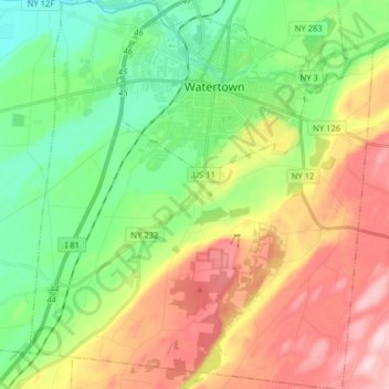
Name: Topografische Karte Town of Watertown, Höhe, Relief.
Ort: Town of Watertown, Jefferson County, New York, United States (43.88506 -75.98706 44.00025 -75.84560)
Durchschnittliche Höhe: 189 m
Minimale Höhe: 87 m
Maximale Höhe: 340 m
Andere topografische Karten
Klicken Sie auf eine Karte, um ihre Topografie, ihre Höhe und ihr Relief anzuzeigen.
Village of Evans Mills
United States > New York > Jefferson County
Village of Evans Mills, Town of Le Ray, Jefferson County, New York, United States
Durchschnittliche Höhe: 139 m
Just Room Enough Island
United States > New York > Jefferson County > Village of Alexandria Bay
Just Room Enough Island, Village of Alexandria Bay, Town of Alexandria, Jefferson County, New York, United States
Durchschnittliche Höhe: 78 m
Village of Black River
United States > New York > Jefferson County
Village of Black River, Town of Le Ray, Jefferson County, New York, United States
Durchschnittliche Höhe: 193 m
Village of Philadelphia
United States > New York > Jefferson County
Village of Philadelphia, Town of Philadelphia, Jefferson County, New York, 13673, United States
Durchschnittliche Höhe: 149 m
Village of Theresa
United States > New York > Jefferson County > Town of Theresa
Village of Theresa, Town of Theresa, Jefferson County, New York, 13691, United States
Durchschnittliche Höhe: 121 m
Black River
United States > New York > Jefferson County > Black River
Black River, Le Ray, Jefferson County, New York, 13612, United States
Durchschnittliche Höhe: 189 m
Whites Bay
United States > New York > Jefferson County
Whites Bay, Henderson, Jefferson County, New York, 13651, United States
Durchschnittliche Höhe: 91 m