
Topografische Karte Amport
Interaktive Karte
Klicken Sie auf die Karte, um die Höhe anzuzeigen.
Über diese Karte
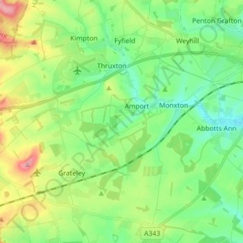
Name: Topografische Karte Amport, Höhe, Relief.
Ort: Amport, Test Valley, Hampshire, England, United Kingdom (51.16207 -1.67238 51.22366 -1.55082)
Durchschnittliche Höhe: 95 m
Minimale Höhe: 56 m
Maximale Höhe: 176 m
Andere topografische Karten
Klicken Sie auf eine Karte, um ihre Topografie, ihre Höhe und ihr Relief anzuzeigen.
West Tytherley
United Kingdom > England > Hampshire > Test Valley
West Tytherley, Test Valley, Hampshire, England, United Kingdom
Durchschnittliche Höhe: 73 m
North Baddesley
United Kingdom > England > Hampshire > Test Valley > North Baddesley
North Baddesley, Test Valley, Hampshire, England, United Kingdom
Durchschnittliche Höhe: 42 m
Bossington
United Kingdom > England > Hampshire > Test Valley
Bossington, Test Valley, Hampshire, England, United Kingdom
Durchschnittliche Höhe: 46 m
Andover
United Kingdom > England > Hampshire > Test Valley > Andover
Andover, Test Valley, Hampshire, England, United Kingdom
Durchschnittliche Höhe: 90 m
Thruxton
United Kingdom > England > Hampshire > Test Valley
Thruxton, Test Valley, Hampshire, England, United Kingdom
Durchschnittliche Höhe: 111 m
Islands
United Kingdom > England > Hampshire > Test Valley > West Tytherley
Islands, West Tytherley, Test Valley, Hampshire, South East England, England, United Kingdom
Durchschnittliche Höhe: 65 m
Sherfield English
United Kingdom > England > Hampshire > Test Valley > Sherfield English
Sherfield English, Test Valley, Hampshire, South East England, England, United Kingdom
Durchschnittliche Höhe: 59 m