
Topografische Karte Westbourne
Klicken Sie auf die Karte, um die Höhe anzuzeigen.
Über diese Karte
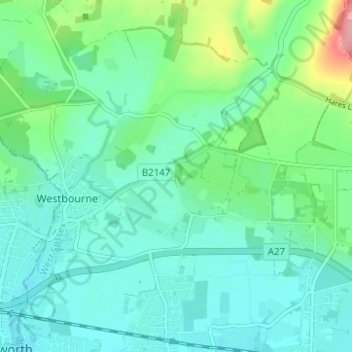
Name: Topografische Karte Westbourne, Höhe, Relief.
Ort: Westbourne, Chichester, West Sussex, England, United Kingdom (50.85322 -0.93883 50.88009 -0.87685)
Durchschnittliche Höhe: 26 m
Minimale Höhe: 1 m
Maximale Höhe: 111 m
Andere topografische Karten
Klicken Sie auf eine Karte, um ihre Topografie, ihre Höhe und ihr Relief anzuzeigen.
Upperton
United Kingdom > England > West Sussex > Chichester > Tillington
Durchschnittliche Höhe: 51 m
Donnington Park
United Kingdom > England > West Sussex > Chichester > Donnington
Durchschnittliche Höhe: 8 m
Adsdean Down
United Kingdom > England > West Sussex > Chichester > Stoughton
Durchschnittliche Höhe: 87 m
Runcton
United Kingdom > England > West Sussex > Chichester > North Mundham
Durchschnittliche Höhe: 6 m
Hill Brow
United Kingdom > England > West Sussex > Chichester > Hill Brow
Durchschnittliche Höhe: 99 m
Benbow Pond
United Kingdom > England > West Sussex > Chichester > Lodsworth
Durchschnittliche Höhe: 55 m
Westerton
United Kingdom > England > West Sussex > Chichester > Westhampnett
Durchschnittliche Höhe: 30 m
Horncroft Common Plantation
United Kingdom > England > West Sussex > Chichester
Durchschnittliche Höhe: 22 m
Maudlin
United Kingdom > England > West Sussex > Chichester > Westhampnett
Durchschnittliche Höhe: 23 m
Blackdown
United Kingdom > England > West Sussex > Chichester
Blackdown, or Black Down, summit elevation 279.7 metres (918 ft) AMSL, is the highest point in both the historic county of Sussex and the South Downs National Park. It is one of the highest points in the south east of England, exceeded by Walbury Hill, Leith Hill and Pilot Hill. Blackdown is protected as part…
Durchschnittliche Höhe: 165 m