
Topografische Karte Town of Amherst
Interaktive Karte
Klicken Sie auf die Karte, um die Höhe anzuzeigen.
Über diese Karte
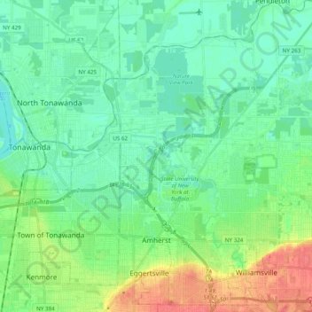
Name: Topografische Karte Town of Amherst, Höhe, Relief.
Ort: Town of Amherst, Erie County, New York, United States (42.94584 -78.83250 43.08708 -78.69684)
Durchschnittliche Höhe: 184 m
Minimale Höhe: 169 m
Maximale Höhe: 220 m
Andere topografische Karten
Klicken Sie auf eine Karte, um ihre Topografie, ihre Höhe und ihr Relief anzuzeigen.
South Wales
United States > New York > Erie County
South Wales, Town of Wales, Erie County, New York, 14139, United States
Durchschnittliche Höhe: 361 m
Sandy Beach
United States > New York > Erie County > Town of Grand Island
Sandy Beach, Town of Grand Island, Erie County, New York, 14304, United States
Durchschnittliche Höhe: 175 m
Albany & School Triangle
United States > New York > Erie County > Buffalo
Albany & School Triangle, Buffalo, Erie County, New York, United States
Durchschnittliche Höhe: 188 m
Town of West Seneca
United States > New York > Erie County
Town of West Seneca, Erie County, New York, 14224, United States
Durchschnittliche Höhe: 200 m
Village of Orchard Park
United States > New York > Erie County > Town of Orchard Park
Village of Orchard Park, Town of Orchard Park, Aurora, Erie County, New York, 14127, United States
Durchschnittliche Höhe: 262 m
Newstead
United States > New York > Erie County
Newstead, Erie County, New York, 14001, United States
Durchschnittliche Höhe: 222 m
Town of Newstead
United States > New York > Erie County
Town of Newstead, Erie County, New York, 14001, United States
Durchschnittliche Höhe: 213 m