
Topografische Karte Stanhope Beach
Interaktive Karte
Klicken Sie auf die Karte, um die Höhe anzuzeigen.
Über diese Karte
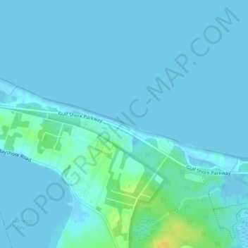
Name: Topografische Karte Stanhope Beach, Höhe, Relief.
Durchschnittliche Höhe: 3 m
Minimale Höhe: -7 m
Maximale Höhe: 22 m
Andere topografische Karten
Klicken Sie auf eine Karte, um ihre Topografie, ihre Höhe und ihr Relief anzuzeigen.
Stanhope Beach
Canada > Prince Edward Island > Queens County > Stanhope
Stanhope Beach, Stanhope, Rural Municipality of North Shore, Queens County, Prince Edward Island, Canada
Durchschnittliche Höhe: 3 m