Geolokalisieren

Topografische Karte Shopian

Klicken Sie auf die Karte, um die Höhe anzuzeigen.

Über diese Karte

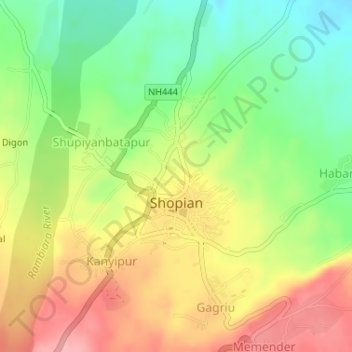
Name: Topografische Karte Shopian, Höhe, Relief.

Ort: Shopian, Shopian District, Jammu and Kashmir, India (33.71300 74.82253 33.72867 74.84543)

Durchschnittliche Höhe: 2.033 m

Minimale Höhe: 1.976 m

Maximale Höhe: 2.092 m

👉 Easily get elevation data in JSON, GeoTIFF and KML formats using Elevation API
Vielen Dank für die Unterstützung dieser Website ❤️
Spenden

Andere topografische Karten

Klicken Sie auf eine Karte, um ihre Topografie, ihre Höhe und ihr Relief anzuzeigen.

Baramulla

India > Jammu and Kashmir

Durchschnittliche Höhe: 1.802 m

Bhaderwah

India > Jammu and Kashmir

Durchschnittliche Höhe: 2.511 m

Pahalgam

India > Jammu and Kashmir > Pahalgam

Pahalgam (Hindustani pronunciation: [pɛhɛlɡaːm]), known as Pahalgom (Kashmiri pronunciation: [pəhəlʲɡoːm]; lit. 'village of shepherds' in Kashmiri) is a town and a notified area committee, near Anantnag city in the Anantnag district of the Indian-administered union territory of Jammu and Kashmir. It…

Durchschnittliche Höhe: 2.700 m

Tral

India > Jammu and Kashmir

Durchschnittliche Höhe: 2.528 m

Gurmul

India > Jammu and Kashmir > Doda

Durchschnittliche Höhe: 2.312 m

Katra

India > Jammu and Kashmir > Reasi

Katra is located at 32°59′N 74°57′E / 32.98°N 74.95°E / 32.98; 74.95. It has an average elevation of 875 metres (2,474 feet). The Banganga River passes through the village.

Durchschnittliche Höhe: 993 m

Samba

India > Jammu and Kashmir

Durchschnittliche Höhe: 462 m

Chandigam

India > Jammu and Kashmir > Handwara tehsil

Durchschnittliche Höhe: 1.854 m

Patnitop

India > Jammu and Kashmir > Ramban

Durchschnittliche Höhe: 1.793 m

Atholi (Paddar)

India > Jammu and Kashmir

Durchschnittliche Höhe: 4.338 m

Shangus tehsil

India > Jammu and Kashmir

Durchschnittliche Höhe: 2.451 m

Assar

India > Jammu and Kashmir > Doda

Durchschnittliche Höhe: 1.169 m

Galandhar

India > Jammu and Kashmir > Pampore

Durchschnittliche Höhe: 1.601 m

Panjar

India > Jammu and Kashmir > Udhampur

Durchschnittliche Höhe: 1.414 m

Kulgam

India > Jammu and Kashmir

Durchschnittliche Höhe: 1.818 m

Reasi

India > Jammu and Kashmir

Durchschnittliche Höhe: 994 m

Sarmar

India > Jammu and Kashmir > Ramban

Durchschnittliche Höhe: 2.338 m

Shopian

India > Jammu and Kashmir

Durchschnittliche Höhe: 2.525 m

Tral

India > Jammu and Kashmir > Tral

Durchschnittliche Höhe: 1.791 m

Uri

India > Jammu and Kashmir

Durchschnittliche Höhe: 2.144 m

Nagri Parole

India > Jammu and Kashmir > Kathua

Durchschnittliche Höhe: 290 m

Mahore

India > Jammu and Kashmir > Gool-Gulabgarh

Durchschnittliche Höhe: 1.384 m

Poterwal

India > Jammu and Kashmir

Durchschnittliche Höhe: 1.878 m

Awantipora

India > Jammu and Kashmir

Durchschnittliche Höhe: 1.665 m

Kumdalan

India > Jammu and Kashmir

Durchschnittliche Höhe: 1.975 m

Bon Dialgam

India > Jammu and Kashmir > Anantnag

Durchschnittliche Höhe: 1.615 m

Katarnag Peak

India > Jammu and Kashmir > Pahalgam

Durchschnittliche Höhe: 4.675 m

Surankote

India > Jammu and Kashmir > Surankote tehsil

Durchschnittliche Höhe: 1.508 m

Pouni

India > Jammu and Kashmir > Reasi

Durchschnittliche Höhe: 628 m

Goose

India > Jammu and Kashmir > Kupwara

Durchschnittliche Höhe: 1.773 m

Teetwal

India > Jammu and Kashmir > Karnah

Durchschnittliche Höhe: 1.448 m

Sempora Pampore

India > Jammu and Kashmir > Srīnagar

Durchschnittliche Höhe: 1.653 m

Pariwan

India > Jammu and Kashmir > Kulgam

Durchschnittliche Höhe: 1.885 m

lahei

India > Jammu and Kashmir > Kalakote

Durchschnittliche Höhe: 826 m

Wotu

India > Jammu and Kashmir > Damhal Hanjipora

Durchschnittliche Höhe: 2.201 m

Kathua

India > Jammu and Kashmir > Kathua

Kathua is located at 32°22′N 75°31′E / 32.37°N 75.52°E / 32.37; 75.52. It has an average elevation of 393 metres (1,289 ft). The city is surrounded by three rivers. Ravi is 7 km (4.3 mi) down Kathua while Ujjh is about 11 km (6.8 mi) ahead on Jammu Highway. Kathua itself is situated along the…

Durchschnittliche Höhe: 411 m

Surinsar Lake

India > Jammu and Kashmir > Jammu

Durchschnittliche Höhe: 577 m

Darhal

India > Jammu and Kashmir

Durchschnittliche Höhe: 1.991 m

Thandal

India > Jammu and Kashmir > Udhampur

Durchschnittliche Höhe: 1.312 m

Kriti

India > Jammu and Kashmir > Kokernag Tehsil

Durchschnittliche Höhe: 2.288 m

dongru

India > Jammu and Kashmir > Doda

Durchschnittliche Höhe: 1.326 m

N8

India > Jammu and Kashmir > Marwah

Durchschnittliche Höhe: 5.497 m

Tailbal(Habak Shanpora)

India > Jammu and Kashmir > Srinagar (North)

Durchschnittliche Höhe: 1.597 m

Sopore

India > Jammu and Kashmir

Durchschnittliche Höhe: 1.683 m

Srandoo

India > Jammu and Kashmir > Kulgam

Durchschnittliche Höhe: 1.669 m

tasnal

India > Jammu and Kashmir > Doda

Durchschnittliche Höhe: 2.074 m

Kokernag

India > Jammu and Kashmir > Kokernag Tehsil

Durchschnittliche Höhe: 2.084 m

Nehama

India > Jammu and Kashmir > Damhal Hanjipora

Durchschnittliche Höhe: 1.961 m

Vielen Dank für die Unterstützung dieser Website ❤️
Spenden

Rüste dich für dein nächstes Abenteuer:

Als Amazon-Partner verdient diese Website an qualifizierten Käufen, ohne zusätzliche Kosten für Sie.

Khanagund

India > Jammu and Kashmir > Pampore

Durchschnittliche Höhe: 2.100 m

Kanthan

India > Jammu and Kashmir > Gool-Gulabgarh

Durchschnittliche Höhe: 820 m

Shar

India > Jammu and Kashmir > Pampore

Durchschnittliche Höhe: 1.688 m

Marwah

India > Jammu and Kashmir

Durchschnittliche Höhe: 4.017 m

Vielen Dank für die Unterstützung dieser Website ❤️
Spenden

Khrew

India > Jammu and Kashmir > Pampore

Khrew is located at 34°01′12″N 74°59′24″E / 34.020°N 74.99°E / 34.020; 74.99. It has an average elevation of 1,607 metres (5,272 feet) and is located in the Kashmir valley. The area starts from Babapora to Seer Bagh and from Bathen to Androosa. Also, the foot region is extended to Ladhoo,…

Durchschnittliche Höhe: 1.788 m

Lam

India > Jammu and Kashmir > Tral

Durchschnittliche Höhe: 2.269 m

Langot

India > Jammu and Kashmir > Kishtwar

Durchschnittliche Höhe: 2.346 m

Kupwara

India > Jammu and Kashmir

Durchschnittliche Höhe: 2.676 m

Chadoora

India > Jammu and Kashmir > Chadoora tehsil

Durchschnittliche Höhe: 1.664 m

Mendhar

India > Jammu and Kashmir

Durchschnittliche Höhe: 1.469 m

Seer Hamdan

India > Jammu and Kashmir

Durchschnittliche Höhe: 1.769 m

Lidderwat

India > Jammu and Kashmir > Pahalgam

Durchschnittliche Höhe: 3.436 m

Srīnagar

India > Jammu and Kashmir

Durchschnittliche Höhe: 2.784 m

MAIYAN

India > Jammu and Kashmir > Boniyar

Durchschnittliche Höhe: 2.339 m

Gulab bagh

India > Jammu and Kashmir > Srinagar (North)

Durchschnittliche Höhe: 1.611 m

swara

India > Jammu and Kashmir > Gandoh

Durchschnittliche Höhe: 2.151 m

Arnia

India > Jammu and Kashmir > Bishnah

Durchschnittliche Höhe: 271 m

Chansir

India > Jammu and Kashmir > Chhatroo > Loi

Durchschnittliche Höhe: 1.712 m

Thalli

India > Jammu and Kashmir > Kishtwar

Durchschnittliche Höhe: 3.619 m

Bistaun

India > Jammu and Kashmir > Atholi (Paddar)

Durchschnittliche Höhe: 2.800 m

dalah

India > Jammu and Kashmir > Bhaderwah

Durchschnittliche Höhe: 1.823 m

Brenawar

India > Jammu and Kashmir > Khansahib tehsil > Branwar

Durchschnittliche Höhe: 2.195 m

Duderhama

India > Jammu and Kashmir > Lar

Durchschnittliche Höhe: 1.631 m

Katwara

India > Jammu and Kashmir > Kupwara

Durchschnittliche Höhe: 2.932 m

Pampore

India > Jammu and Kashmir > Pampore

Durchschnittliche Höhe: 2.015 m

Gagangir

India > Jammu and Kashmir > Kangan

Durchschnittliche Höhe: 2.795 m

Amarnath Cave Temple

India > Jammu and Kashmir > Pahalgam

The Shiva Lingam at the shrine is a Swayambhu lingam. The lingam is a natural stalagmite formation located at the Amarnath Mountain which has a peak of 5,186 metres (17,014 ft), and inside a 40 m (130 ft) high cave at an elevation of 3,888 m (12,756 ft). The stalagmite is formed due to the freezing of water…

Durchschnittliche Höhe: 4.325 m

Bandipora

India > Jammu and Kashmir

Durchschnittliche Höhe: 2.703 m

Chatru

India > Jammu and Kashmir > Chhatroo

Durchschnittliche Höhe: 1.891 m

Anantnag district

India > Jammu and Kashmir

"Sir Walter Lawrence writes in his book The Valley of Kashmir that in latitude Kashmir corresponds with Peshawar, Baghdad and Damascus in Asia: with Fez in Morocco: and South Carolina in America, but it presents none of the characteristics of those countries. People have linked the climate of Kashmir to that…

Durchschnittliche Höhe: 2.830 m

Kangan

India > Jammu and Kashmir > Kangan

Durchschnittliche Höhe: 3.335 m

Kathua

India > Jammu and Kashmir

Durchschnittliche Höhe: 498 m

Vielen Dank für die Unterstützung dieser Website ❤️
Spenden

Jangalwar

India > Jammu and Kashmir > Doda > Phagsoo

Durchschnittliche Höhe: 1.353 m

Badgam tehsil

India > Jammu and Kashmir

Durchschnittliche Höhe: 1.644 m

Kokernag Tehsil

India > Jammu and Kashmir

Durchschnittliche Höhe: 2.646 m

Rajauri

India > Jammu and Kashmir

Durchschnittliche Höhe: 1.415 m

Rajouri

India > Jammu and Kashmir > Rajauri

Rajouri is located at 33°23′N 74°18′E / 33.38°N 74.3°E / 33.38; 74.3. It has an average elevation of 915 metres (3001 feet).

Durchschnittliche Höhe: 1.038 m

Banihal

India > Jammu and Kashmir

Durchschnittliche Höhe: 2.478 m

Kishtwar

India > Jammu and Kashmir

Durchschnittliche Höhe: 2.605 m

hanzal

India > Jammu and Kashmir > Marwah > hanzal

Durchschnittliche Höhe: 2.503 m

Lar

India > Jammu and Kashmir > Lar

Durchschnittliche Höhe: 2.024 m

Ramban

India > Jammu and Kashmir

Durchschnittliche Höhe: 1.764 m

Said pora

India > Jammu and Kashmir > Srinagar (South) > Said pora

Durchschnittliche Höhe: 1.588 m

dharni

India > Jammu and Kashmir > Banihal > dharni

Durchschnittliche Höhe: 1.840 m

Doda

India > Jammu and Kashmir

Durchschnittliche Höhe: 2.212 m

Bani

India > Jammu and Kashmir

Durchschnittliche Höhe: 2.300 m

Udhampur

India > Jammu and Kashmir

Durchschnittliche Höhe: 1.292 m

chatra

India > Jammu and Kashmir > Bhaderwah > chatra

Durchschnittliche Höhe: 1.837 m

Vielen Dank für die Unterstützung dieser Website ❤️
Spenden

Rüste dich für dein nächstes Abenteuer:

Als Amazon-Partner verdient diese Website an qualifizierten Käufen, ohne zusätzliche Kosten für Sie.

dedan

India > Jammu and Kashmir > Doda > dedan

Durchschnittliche Höhe: 2.329 m

Ganderbal

India > Jammu and Kashmir

Durchschnittliche Höhe: 1.885 m

Baltal

India > Jammu and Kashmir

Durchschnittliche Höhe: 3.160 m

Nowshehra Tehsil

India > Jammu and Kashmir > Nowshehra Tehsil

Durchschnittliche Höhe: 800 m

Rüste dich für dein nächstes Abenteuer:

🥾Trekkingschuhe - Vielseitige Schuhe für anspruchsvolle Mehrtagestouren
🎒Rucksack 50L - Perfekt für mehrtägige Touren mit Ausrüstung
📡Outdoor Funkgeräte - Kommunikation ohne Netz
🛖Hüttenschlafsack Baumwolle - Vorgeschrieben für Übernachtungen auf Alpenvereinshütten
📡Satelliten-Notfallsender - Maximale Sicherheit in Gebieten ohne Mobilfunknetz

Als Amazon-Partner verdient diese Website an qualifizierten Käufen, ohne zusätzliche Kosten für Sie.