
Topografische Karte Haut-Rhin
Interaktive Karte
Klicken Sie auf die Karte, um die Höhe anzuzeigen.
Über diese Karte
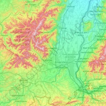
Name: Topografische Karte Haut-Rhin, Höhe, Relief.
Ort: Haut-Rhin, Grand Est, France métropolitaine, France (47.42034 6.84132 48.31134 7.62201)
Durchschnittliche Höhe: 444 m
Minimale Höhe: 155 m
Maximale Höhe: 1.392 m
Il est limitrophe des départements du Bas-Rhin, des Vosges et du Territoire de Belfort. Il partage 66,44 kilomètres de frontières avec l'Allemagne à l'est (land du Bade-Wurtemberg), le long du Rhin, et 78,37 km avec la Suisse au sud (cantons du Jura, de Soleure, de Bâle-Campagne et de Bâle-Ville). Le point culminant du Haut-Rhin est le Grand Ballon, point culminant du massif des Vosges à 1 424 m d'altitude ; et le point le plus bas à 179 m, le long du Rhin.
Andere topografische Karten
Klicken Sie auf eine Karte, um ihre Topografie, ihre Höhe und ihr Relief anzuzeigen.
Nancy
France > Grand Est > Meurthe-et-Moselle
Nancy, Meurthe-et-Moselle, Grand Est, France métropolitaine, France
Durchschnittliche Höhe: 230 m
Colroy-la-Roche
Colroy-la-Roche, Molsheim, Bas-Rhin, Grand Est, France métropolitaine, 67420, France
Durchschnittliche Höhe: 574 m
Strasbourg
Strasbourg, Bas-Rhin, Grand Est, France métropolitaine, France
Durchschnittliche Höhe: 144 m
Sarcey
France > Grand Est > Haute-Marne
Sarcey, Chaumont, Haute-Marne, Grand Est, France métropolitaine, 52800, France
Durchschnittliche Höhe: 393 m
Vahl-lès-Bénestroff
Vahl-lès-Bénestroff, Sarrebourg-Château-Salins, Moselle, Grand Est, France métropolitaine, 57670, France
Durchschnittliche Höhe: 246 m
Sous les Prés la Joue
France > Grand Est > Meurthe-et-Moselle > Villers-la-Montagne
Sous les Prés la Joue, Villers-la-Montagne, Val-de-Briey, Meurthe-et-Moselle, Grand Est, France métropolitaine, 54920, France
Durchschnittliche Höhe: 374 m
Artaise-le-Vivier
Artaise-le-Vivier, Sedan, Ardennes, Grand Est, France métropolitaine, 08390, France
Durchschnittliche Höhe: 212 m
Humbauville
Humbauville, Vitry-le-François, Marne, Grand Est, France métropolitaine, 51320, France
Durchschnittliche Höhe: 167 m
57280
France > Grand Est > Moselle > Hauconcourt
57280, Hauconcourt, Metz, Moselle, Grand Est, France métropolitaine, France
Durchschnittliche Höhe: 164 m
Saint-Dié-des-Vosges
Saint-Dié-des-Vosges, Vosges, Grand Est, France métropolitaine, 88100, France
Durchschnittliche Höhe: 433 m
Drachenbronn-Birlenbach
Drachenbronn-Birlenbach, Haguenau-Wissembourg, Bas-Rhin, Grand Est, France métropolitaine, 67160, France
Durchschnittliche Höhe: 225 m
Vaucouleurs
Vaucouleurs, Commercy, Meuse, Grand Est, France métropolitaine, 55140, France
Durchschnittliche Höhe: 301 m
54400
France > Grand Est > Meurthe-et-Moselle > Cosnes-et-Romain
54400, Cosnes-et-Romain, Val-de-Briey, Meurthe-et-Moselle, Grand Est, France métropolitaine, France
Durchschnittliche Höhe: 372 m
Givrycourt
Givrycourt, Sarrebourg-Château-Salins, Moselle, Grand Est, France métropolitaine, 57670, France
Durchschnittliche Höhe: 231 m
Seingbouse
Seingbouse, Forbach-Boulay-Moselle, Moselle, Grand Est, France métropolitaine, 57455, France
Durchschnittliche Höhe: 293 m
Charleville
Charleville, Épernay, Marne, Grand Est, France métropolitaine, 51120, France
Durchschnittliche Höhe: 203 m
Étang de Fleckenstein
France > Grand Est > Bas-Rhin > Lembach
Étang de Fleckenstein, Lembach, Haguenau-Wissembourg, Bas-Rhin, Grand Est, France métropolitaine, 67510, France
Durchschnittliche Höhe: 304 m
Haute-Marne
Haute-Marne, Grand Est, France métropolitaine, France
Durchschnittliche Höhe: 308 m
Bar-le-Duc
Bar-le-Duc, Meuse, Grand Est, France métropolitaine, 55000, France
Durchschnittliche Höhe: 253 m
Mondelange
Mondelange, Thionville, Moselle, Grand Est, France métropolitaine, 57300, France
Durchschnittliche Höhe: 162 m
Rue du Moulin
France > Grand Est > Aube > Argançon
Rue du Moulin, Argançon, Bar-sur-Aube, Aube, Grand Est, France métropolitaine, 10140, France
Durchschnittliche Höhe: 215 m
Les Longues Fauchées
France > Grand Est > Meuse > Étain
Les Longues Fauchées, Étain, Verdun, Meuse, Grand Est, France métropolitaine, 55400, France
Durchschnittliche Höhe: 208 m
Bogny-sur-Meuse
Bogny-sur-Meuse, Charleville-Mézières, Ardennes, Grand Est, France métropolitaine, 08120, France
Durchschnittliche Höhe: 242 m
Rouchamp
France > Grand Est > Meuse > Seigneulles
Rouchamp, Seigneulles, Bar-le-Duc, Meuse, Grand Est, France métropolitaine, 55000, France
Durchschnittliche Höhe: 302 m
Liffol-le-Grand
Liffol-le-Grand, Neufchâteau, Vosges, Grand Est, France métropolitaine, 88350, France
Durchschnittliche Höhe: 360 m