
Spenden
Rüste dich für dein nächstes Abenteuer:
Als Amazon-Partner verdient diese Website an qualifizierten Käufen, ohne zusätzliche Kosten für Sie.
Topografische Karte Slingerlands
Klicken Sie auf die Karte, um die Höhe anzuzeigen.
Spenden
Rüste dich für dein nächstes Abenteuer:
Als Amazon-Partner verdient diese Website an qualifizierten Käufen, ohne zusätzliche Kosten für Sie.
Über diese Karte
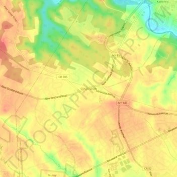
Name: Topografische Karte Slingerlands, Höhe, Relief.
Durchschnittliche Höhe: 65 m
Minimale Höhe: 28 m
Maximale Höhe: 84 m
Spenden
Rüste dich für dein nächstes Abenteuer:
Als Amazon-Partner verdient diese Website an qualifizierten Käufen, ohne zusätzliche Kosten für Sie.
Andere topografische Karten
Klicken Sie auf eine Karte, um ihre Topografie, ihre Höhe und ihr Relief anzuzeigen.
City of Albany
United States > New York > Albany County
The highest natural point in Albany is a USGS benchmark near the Loudonville Reservoir off Birch Hill Road, at 378 feet (115 m) above sea level. The lowest point is sea level at the Hudson River (the average water elevation is 2 feet (0.61 m)), which is still technically an estuary at Albany and is affected by…
Durchschnittliche Höhe: 68 m
Village of Menands
United States > New York > Albany County > Town of Colonie
Durchschnittliche Höhe: 34 m
Spenden
Rüste dich für dein nächstes Abenteuer:
Als Amazon-Partner verdient diese Website an qualifizierten Käufen, ohne zusätzliche Kosten für Sie.
Spenden
Rüste dich für dein nächstes Abenteuer:
Als Amazon-Partner verdient diese Website an qualifizierten Käufen, ohne zusätzliche Kosten für Sie.
Henry Johnson Park
United States > New York > Albany County > City of Albany
Durchschnittliche Höhe: 51 m
Village of Green Island
United States > New York > Albany County > Town of Colonie
Durchschnittliche Höhe: 19 m
Spenden
Rüste dich für dein nächstes Abenteuer:
Als Amazon-Partner verdient diese Website an qualifizierten Käufen, ohne zusätzliche Kosten für Sie.
Preston-Potter Hollow
United States > New York > Albany County > Town of Rensselaerville
It is also the topographical location of Potter Hollow.
Durchschnittliche Höhe: 371 m
Spenden
Rüste dich für dein nächstes Abenteuer:
Als Amazon-Partner verdient diese Website an qualifizierten Käufen, ohne zusätzliche Kosten für Sie.
Village of Voorheesville
United States > New York > Albany County > Town of New Scotland
Durchschnittliche Höhe: 107 m
Siena College
United States > New York > Albany County > Town of Colonie > Newtonville
Durchschnittliche Höhe: 98 m
Spenden
Rüste dich für dein nächstes Abenteuer:
Als Amazon-Partner verdient diese Website an qualifizierten Käufen, ohne zusätzliche Kosten für Sie.
Village of Altamont
United States > New York > Albany County > Town of Guilderland
Durchschnittliche Höhe: 158 m
Spenden
Rüste dich für dein nächstes Abenteuer:
Als Amazon-Partner verdient diese Website an qualifizierten Käufen, ohne zusätzliche Kosten für Sie.
Spenden
Rüste dich für dein nächstes Abenteuer:
Als Amazon-Partner verdient diese Website an qualifizierten Käufen, ohne zusätzliche Kosten für Sie.
Village of Menands
United States > New York > Albany County > Town of Colonie
Durchschnittliche Höhe: 34 m
Spenden
Rüste dich für dein nächstes Abenteuer:
Als Amazon-Partner verdient diese Website an qualifizierten Käufen, ohne zusätzliche Kosten für Sie.
Spenden
Rüste dich für dein nächstes Abenteuer:
Als Amazon-Partner verdient diese Website an qualifizierten Käufen, ohne zusätzliche Kosten für Sie.
Medusa
United States > New York > Albany County
Medusa is located at 42°26′12″N 074°07′48″W / 42.43667°N 74.13000°W / 42.43667; -74.13000 (42.4367469, -74.1301365) and its elevation is 804 feet (245 m).
Durchschnittliche Höhe: 297 m
City of Albany
United States > New York > Albany County
The highest natural point in Albany is a USGS benchmark near the Loudonville Reservoir off Birch Hill Road, at 378 feet (115 m) above sea level. The lowest point is sea level at the Hudson River (the average water elevation is 2 feet (0.61 m)), which is still technically an estuary at Albany and is affected by…
Durchschnittliche Höhe: 68 m
Spenden
Rüste dich für dein nächstes Abenteuer:
Als Amazon-Partner verdient diese Website an qualifizierten Käufen, ohne zusätzliche Kosten für Sie.