
Topografische Karte Osorno Volcano
Interaktive Karte
Klicken Sie auf die Karte, um die Höhe anzuzeigen.
Über diese Karte
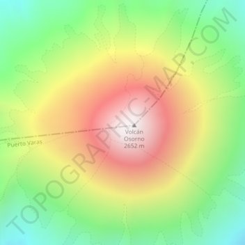
Name: Topografische Karte Osorno Volcano, Höhe, Relief.
Durchschnittliche Höhe: 1.994 m
Minimale Höhe: 1.368 m
Maximale Höhe: 2.661 m
The basalt and andesite lava flows generated during these eruptions reached both Lago Llanquihue and Lago Todos Los Santos. The upper slopes of the volcano are almost entirely covered in glaciers despite its very modest altitude and latitude, sustained by the substantial annual snowfall in the very moist maritime climate of the region. Osorno has also historically produced pyroclastic flow, since it is a composite volcano. The volcano has been noted for its similar appearance to Mount Fuji in Japan.
Andere topografische Karten
Klicken Sie auf eine Karte, um ihre Topografie, ihre Höhe und ihr Relief anzuzeigen.
Nueva Braunau
Chile > Los Lagos Region > Provincia de Llanquihue > Puerto Varas
Nueva Braunau, Puerto Varas, Provincia de Llanquihue, Los Lagos Region, Chile
Durchschnittliche Höhe: 105 m
Volcán Calbuco
Chile > Los Lagos Region > Provincia de Llanquihue > Puerto Varas
Volcán Calbuco, Puerto Varas, Provincia de Llanquihue, Los Lagos Region, Chile
Durchschnittliche Höhe: 1.581 m