
Topografische Karte Cypress Hill
Interaktive Karte
Klicken Sie auf die Karte, um die Höhe anzuzeigen.
Über diese Karte
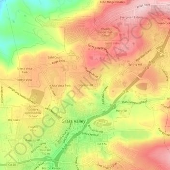
Name: Topografische Karte Cypress Hill, Höhe, Relief.
Durchschnittliche Höhe: 786 m
Minimale Höhe: 636 m
Maximale Höhe: 892 m
Andere topografische Karten
Klicken Sie auf eine Karte, um ihre Topografie, ihre Höhe und ihr Relief anzuzeigen.
Hills Flat
United States > California > Nevada County > Grass Valley
Hills Flat, Grass Valley, Nevada County, California, 95945, United States
Durchschnittliche Höhe: 802 m
Grass Valley
United States > California > Nevada County > Grass Valley
Grass Valley, Nevada County, California, United States
Durchschnittliche Höhe: 775 m
Spring Hill
United States > California > Nevada County > Grass Valley > Spring Hill
Spring Hill, Grass Valley, Nevada County, California, 95954, United States
Durchschnittliche Höhe: 807 m
Boston Ravine
United States > California > Nevada County > Grass Valley
Boston Ravine, Grass Valley, Nevada County, California, 95945, United States
Durchschnittliche Höhe: 755 m