
Topografische Karte Lake Titicaca
Interaktive Karte
Klicken Sie auf die Karte, um die Höhe anzuzeigen.
Über diese Karte
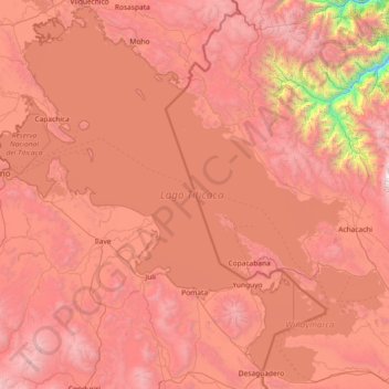
Name: Topografische Karte Lake Titicaca, Höhe, Relief.
Ort: Lake Titicaca, Puno, Peru (-16.59816 -70.03591 -15.23333 -68.56834)
Durchschnittliche Höhe: 3.870 m
Minimale Höhe: 1.428 m
Maximale Höhe: 5.797 m
Lake Titicaca has a surface elevation of 3,812 m (12,507 ft). The "highest lake" claim is generally considered to refer to commercial craft. Numerous smaller bodies of water (that are not considered lakes) around the world are at higher elevations. For many years, the largest vessel afloat on the lake was the 2,200-ton (2,425 U.S. tons), 79 m (259 ft) SS Ollanta. Today, the largest vessel is most likely the similarly sized train barge/float Manco Capac, operated by PeruRail.
Andere topografische Karten
Klicken Sie auf eine Karte, um ihre Topografie, ihre Höhe und ihr Relief anzuzeigen.
Cunurana
Peru > Puno > Santa Rosa
Cunurana, Santa Rosa, Province of Melgar, Puno, Peru
Durchschnittliche Höhe: 4.912 m
Laguna Parinacota
Laguna Parinacota, Kelluyo, Province of Chucuito, Puno, Peru
Durchschnittliche Höhe: 3.825 m
La Rinconada
La Rinconada, Ananea, Province of San Antonio de Putina, Puno, Peru
Durchschnittliche Höhe: 4.923 m
San Fracisco
San Fracisco, Putina, Province of San Antonio de Putina, Puno, Peru
Durchschnittliche Höhe: 3.902 m
Titicaca National Reserve
Titicaca National Reserve, Province of Puno, Puno, Peru
Durchschnittliche Höhe: 3.843 m
Altagracia
Peru > Puno > Antauta > Altagracia
Altagracia, Antauta, Province of Melgar, Puno, Peru
Durchschnittliche Höhe: 4.251 m
Santa María
Peru > Puno > Ilave > Santa María
Santa María, Ilave, Province of El Collao, Puno, Peru
Durchschnittliche Höhe: 3.859 m
Province of San Antonio de Putina
Peru > Puno > Quilcapuncu
Province of San Antonio de Putina, Quilcapuncu, San Antonio de Putina, Puno, Peru
Durchschnittliche Höhe: 4.425 m