
Topografische Karte Lake San Cristobal
Interaktive Karte
Klicken Sie auf die Karte, um die Höhe anzuzeigen.
Über diese Karte
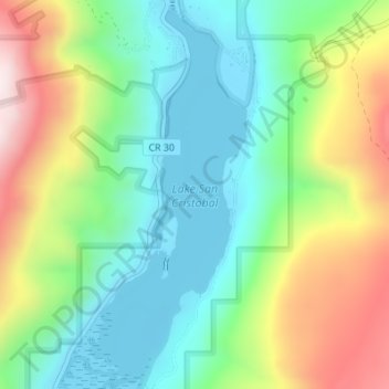
Name: Topografische Karte Lake San Cristobal, Höhe, Relief.
Durchschnittliche Höhe: 2.947 m
Minimale Höhe: 2.744 m
Maximale Höhe: 3.326 m
Lake San Cristobal is a lake in the U.S. state of Colorado. Located in the San Juan Mountains at an elevation of 9,003 feet (2,744 m), the freshwater lake is 2.1 miles (3.4 km) long, up to 89 feet (27 m) deep, has a surface area of 0.52 square miles (1.3 km2), and holds about 11,000 acre-feet (14,000,000 m3) of water. The town of Lake City, a few miles to the north, is named after Lake San Cristobal. The name San Cristóbal means Saint Christopher in the Spanish language. Many old silver mines are near the lake and it is very clean and well kept, and stocked with Rainbow Trout.
Andere topografische Karten
Klicken Sie auf eine Karte, um ihre Topografie, ihre Höhe und ihr Relief anzuzeigen.
Lake City
United States > Colorado > Hinsdale County > Lake City
Lake City, Hinsdale County, Colorado, United States
Durchschnittliche Höhe: 2.834 m