
Topografische Karte Govardhan
Interaktive Karte
Klicken Sie auf die Karte, um die Höhe anzuzeigen.
Über diese Karte
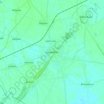
Name: Topografische Karte Govardhan, Höhe, Relief.
Durchschnittliche Höhe: 181 m
Minimale Höhe: 177 m
Maximale Höhe: 188 m
Govardhana is located at 27°30′N 77°28′E / 27.5°N 77.47°E / 27.5; 77.47. It has an average elevation of 179 metres (587 feet). Govardhana has been made Tehsil in Mathura District by the Uttar Pradesh government.
Andere topografische Karten
Klicken Sie auf eine Karte, um ihre Topografie, ihre Höhe und ihr Relief anzuzeigen.
Khajuri
India > Uttar Pradesh > Mathura > Khajuri
Khajuri, Mahavan, Mathura, Agra division, Uttar Pradesh, 281206, India
Durchschnittliche Höhe: 177 m
Ajhai Khurd
India > Uttar Pradesh > Mathura > Ajhai Khurd
Ajhai Khurd, Chhata, Mathura, Uttar Pradesh, 281406, India
Durchschnittliche Höhe: 183 m
Vrindavan
India > Uttar Pradesh > Mathura
Vrindavan, Mathura, Agra division, Uttar Pradesh, 281121, India
Durchschnittliche Höhe: 172 m