
Topografische Karte Sirte
Interaktive Karte
Klicken Sie auf die Karte, um die Höhe anzuzeigen.
Über diese Karte
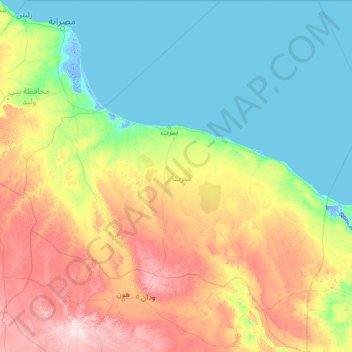
Name: Topografische Karte Sirte, Höhe, Relief.
Ort: Sirte, Libya (28.48467 14.56254 32.70054 19.38007)
Durchschnittliche Höhe: 162 m
Minimale Höhe: -12 m
Maximale Höhe: 815 m
The boundaries of Sirte district have changed several times, most recently in the 2007 administrative reorganization of Libyan districts (see maps). From 1983 to 1987 the Bin Jawad District covered parts of what is now part of Sirte District. To the north, Sirte District has a shoreline on the Mediterranean Sea. As of 2007, on land, it bordered the following districts, namely, Al Wahat in the east, Jufra in the south, Jabal al Gharbi in the west and Misrata in the northwest. Sirte is an interim destination of a coastal railway from Tunisia to Benghazi that began construction in 2007. Sirte is a part of Triplotania geographical region of Libya that runs from north to south and has set of coastal oases, plains and limestone plateaus having an elevation of 2,000 ft (610 m) to 3,000 ft (910 m). The region receives an annual rainfall of 16 in (410 mm). There are no perennial rivers in the region, but the region is abundant with groundwater aquifers. Libya has mostly a flat undulating plain and occasional plateau, with an average elevation of around 423 m (1,388 ft). Around 91 per cent of the land is covered by desert, with only 8.8 per cent agricultural land (with only 1% arable lands) and 0.1 per cent of forests. Along the coastal regions, the climate is Mediterranean, while it is desert climate in all other parts. Dust storms lasting four to eight days is pretty common during Spring. Triplotania is the northwest region, while it is Cyrenacia in the east and Fezzen in southwest.
Andere topografische Karten
Klicken Sie auf eine Karte, um ihre Topografie, ihre Höhe und ihr Relief anzuzeigen.
Qabilat az Zintan al `Umyan
Qabilat az Zintan al `Umyan, Jabal al Gharbi, Libya
Durchschnittliche Höhe: 544 m
Qabilat Sidi Mu`ammar
Qabilat Sidi Mu`ammar, Murqub, Libya
Durchschnittliche Höhe: 336 m
Old city of Tripoli
Old city of Tripoli, Tripoli, Libya
Durchschnittliche Höhe: 7 m
dar bin sweedan
Libya > Jafara > Al-Nasiriyya
dar bin sweedan, Al-Nasiriyya, Jafara, Libya
Durchschnittliche Höhe: 94 m
Jebel Akhdar
Jebel Akhdar, Jabal al Akhdar, Libya
Durchschnittliche Höhe: 847 m
Bi`r Abu al Ghurab
Libya > Jabal al Gharbi > Bi`r Abu al Ghurab
Bi`r Abu al Ghurab, Jabal al Gharbi, Libya
Durchschnittliche Höhe: 332 m
Al Fuqaha`
Libya > District of Al-Jufra > Al Fuqaha`
Al Fuqaha`, District of Al-Jufra, Libya
Durchschnittliche Höhe: 534 m
Awlad `Isa
Libya > Jabal al Gharbi > Awlad `Isa
Awlad `Isa, Jabal al Gharbi, Libya
Durchschnittliche Höhe: 689 m
Temzghurah
Libya > Jabal al Gharbi > Temzghurah
Temzghurah, Jabal al Gharbi, Libya
Durchschnittliche Höhe: 565 m
Suknah
Libya > District of Al-Jufra > Suknah
Suknah, District of Al-Jufra, Libya
Durchschnittliche Höhe: 295 m
Al Sahqeeqa
Libya > Jabal al Gharbi > Al Sahqeeqa
Al Sahqeeqa, Jabal al Gharbi, Libya
Durchschnittliche Höhe: 595 m
Awlad Abd al Jalil
Libya > Jabal al Gharbi > Awlad Abd al Jalil
Awlad Abd al Jalil, Jabal al Gharbi, Libya
Durchschnittliche Höhe: 639 m
Tindbas
Libya > Jabal al Gharbi > Tindbas
Tindbas, Jabal al Gharbi, Libya
Durchschnittliche Höhe: 597 m