
Topografische Karte Cedar Bluffs
Interaktive Karte
Klicken Sie auf die Karte, um die Höhe anzuzeigen.
Über diese Karte
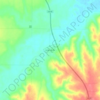
Name: Topografische Karte Cedar Bluffs, Höhe, Relief.
Ort: Cedar Bluffs, Decatur County, Kansas, United States (39.95889 -100.58181 39.99889 -100.54181)
Durchschnittliche Höhe: 794 m
Minimale Höhe: 768 m
Maximale Höhe: 835 m
Andere topografische Karten
Klicken Sie auf eine Karte, um ihre Topografie, ihre Höhe und ihr Relief anzuzeigen.
Oberlin
United States > Kansas > Decatur County
Oberlin, Decatur County, Kansas, 67749, United States
Durchschnittliche Höhe: 794 m
Dresden
United States > Kansas > Decatur County
Dresden, Decatur County, Kansas, 67635, United States
Durchschnittliche Höhe: 828 m
Jennings
United States > Kansas > Decatur County
Jennings, Decatur County, Kansas, 67643, United States
Durchschnittliche Höhe: 769 m
Leoville
United States > Kansas > Decatur County
Leoville, Decatur County, Kansas, United States
Durchschnittliche Höhe: 842 m