
Topografische Karte Bredasdorp
Interaktive Karte
Klicken Sie auf die Karte, um die Höhe anzuzeigen.
Über diese Karte
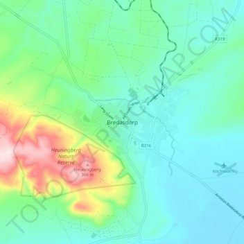
Name: Topografische Karte Bredasdorp, Höhe, Relief.
Durchschnittliche Höhe: 104 m
Minimale Höhe: 17 m
Maximale Höhe: 384 m
Bredasdorp is situated at an elevation of between 40 and 120 metres (130 and 390 ft) on the slopes of the Heuningberg (Afrikaans for "Honey Mountain"). There is no significant watercourse flowing through the town, although the Kars Rivier flows past a few kilometres to the east.
Andere topografische Karten
Klicken Sie auf eine Karte, um ihre Topografie, ihre Höhe und ihr Relief anzuzeigen.
Arniston
South Africa > Western Cape > Overberg District Municipality > Cape Agulhas Local Municipality
Arniston, Cape Agulhas Local Municipality, Overberg District Municipality, Western Cape, South Africa
Durchschnittliche Höhe: 13 m
Struisbaai
South Africa > Western Cape > Overberg District Municipality > Cape Agulhas Local Municipality > Molshoop
Struisbaai, Cape Agulhas Ward 5, Molshoop, Cape Agulhas Local Municipality, Overberg District Municipality, Western Cape, 7285, South Africa
Durchschnittliche Höhe: 27 m
Bredasdorp
South Africa > Western Cape > Overberg District Municipality > Cape Agulhas Local Municipality
Bredasdorp, Cape Agulhas Local Municipality, Overberg District Municipality, Western Cape, 7280, South Africa
Durchschnittliche Höhe: 101 m
Skipskop
South Africa > Western Cape > Overberg District Municipality > Cape Agulhas Local Municipality
Skipskop, Cape Agulhas Ward 4, Cape Agulhas Local Municipality, Overberg District Municipality, Western Cape, South Africa
Durchschnittliche Höhe: 10 m
De Hoop Nature Reserve
South Africa > Western Cape > Overberg District Municipality > Cape Agulhas Local Municipality
De Hoop Nature Reserve, Cape Agulhas Ward 4, Cape Agulhas Local Municipality, Overberg District Municipality, Western Cape, 7280, South Africa
Durchschnittliche Höhe: 63 m
De Mond Nature Reserve
South Africa > Western Cape > Overberg District Municipality > Cape Agulhas Local Municipality
De Mond Nature Reserve, Gravel Road, Cape Agulhas Ward 6, Cape Agulhas Local Municipality, Overberg District Municipality, Western Cape, South Africa
Durchschnittliche Höhe: 5 m