
Topografische Karte Mont
Interaktive Karte
Klicken Sie auf die Karte, um die Höhe anzuzeigen.
Über diese Karte
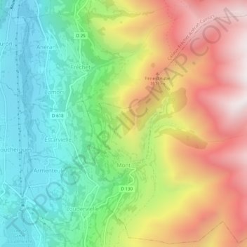
Name: Topografische Karte Mont, Höhe, Relief.
Durchschnittliche Höhe: 1.336 m
Minimale Höhe: 904 m
Maximale Höhe: 1.922 m
Andere topografische Karten
Klicken Sie auf eine Karte, um ihre Topografie, ihre Höhe und ihr Relief anzuzeigen.
Castelnau-Magnoac
France > Occitania > Hautes Pyrenees
Castelnau-Magnoac, Tarbes, Hautes Pyrenees, Occitania, Metropolitan France, 65230, France
Durchschnittliche Höhe: 307 m
Baylen
France > Occitania > Hautes Pyrenees > Castelnau-Rivière-Basse
Baylen, Castelnau-Rivière-Basse, Tarbes, Hautes Pyrenees, Occitania, Metropolitan France, 65700, France
Durchschnittliche Höhe: 191 m
Darré Peyrahitte
France > Occitania > Hautes Pyrenees > Lies
Darré Peyrahitte, Lies, Bagnères-de-Bigorre, Hautes Pyrenees, Occitania, Metropolitan France, 65200, France
Durchschnittliche Höhe: 693 m
Maubourguet
France > Occitania > Hautes Pyrenees
Maubourguet, Tarbes, Hautes Pyrenees, Occitania, Metropolitan France, 65700, France
Durchschnittliche Höhe: 186 m
Arrens-Marsous
France > Occitania > Hautes Pyrenees
Arrens-Marsous, Argelès-Gazost, Hautes Pyrenees, Occitania, Metropolitan France, 65400, France
Durchschnittliche Höhe: 1.714 m
Uz
France > Occitania > Hautes Pyrenees
Uz, Argelès-Gazost, Hautes Pyrenees, Occitania, Metropolitan France, 65400, France
Durchschnittliche Höhe: 794 m
Villemur
France > Occitania > Hautes Pyrenees
Villemur, Tarbes, Hautes Pyrenees, Occitania, Metropolitan France, 65230, France
Durchschnittliche Höhe: 382 m
Arreau
France > Occitania > Hautes Pyrenees
Arreau, Bagnères-de-Bigorre, Hautes Pyrenees, Occitania, Metropolitan France, 65240, France
Durchschnittliche Höhe: 1.022 m
Sarrancolin
France > Occitania > Hautes Pyrenees
Sarrancolin, Bagnères-de-Bigorre, Hautes Pyrenees, Occitania, Metropolitan France, 65410, France
Durchschnittliche Höhe: 1.145 m
Lourdes
France > Occitania > Hautes Pyrenees
Lourdes, Argelès-Gazost, Hautes Pyrenees, Occitania, Metropolitan France, 65100, France
Durchschnittliche Höhe: 514 m
Marseillan
France > Occitania > Hautes Pyrenees
Marseillan, Tarbes, Hautes Pyrenees, Occitania, Metropolitan France, 65350, France
Durchschnittliche Höhe: 242 m
Vignec
France > Occitania > Hautes Pyrenees
Vignec, Bagnères-de-Bigorre, Hautes Pyrenees, Occitania, Metropolitan France, 65170, France
Durchschnittliche Höhe: 1.232 m
Hautacam
France > Occitania > Hautes Pyrenees > Beaucens
Hautacam, Beaucens, Argelès-Gazost, Hautes Pyrenees, Occitania, Metropolitan France, 65400, France
Durchschnittliche Höhe: 1.486 m
Lesponne
France > Occitania > Hautes Pyrenees > Bagnères-de-Bigorre
Lesponne, Bagnères-de-Bigorre, Hautes Pyrenees, Occitania, Metropolitan France, 65710, France
Durchschnittliche Höhe: 1.004 m
Payolle
France > Occitania > Hautes Pyrenees > Campan
Payolle, Campan, Bagnères-de-Bigorre, Hautes Pyrenees, Occitania, Metropolitan France, 65710, France
Durchschnittliche Höhe: 1.281 m
La Raillère
France > Occitania > Hautes Pyrenees > Cauterets
La Raillère, Cauterets, Argelès-Gazost, Hautes Pyrenees, Occitania, Metropolitan France, 65110, France
Durchschnittliche Höhe: 1.603 m
Ibos
France > Occitania > Hautes Pyrenees
Ibos, Tarbes, Hautes Pyrenees, Occitania, Metropolitan France, 65420, France
Durchschnittliche Höhe: 333 m
Peyresourde-Balestas
France > Occitania > Hautes Pyrenees > Germ
Peyresourde-Balestas, Germ, Bagnères-de-Bigorre, Hautes Pyrenees, Occitania, Metropolitan France, 65240, France
Durchschnittliche Höhe: 1.559 m
Marsous
France > Occitania > Hautes Pyrenees
Marsous, Arrens-Marsous, Argelès-Gazost, Hautes Pyrenees, Occitania, Metropolitan France, 65400, France
Durchschnittliche Höhe: 1.067 m
Cazaux-Debat
France > Occitania > Hautes Pyrenees > Cazaux-Fréchet-Anéran-Camors
Cazaux-Debat, Cazaux-Fréchet-Anéran-Camors, Bagnères-de-Bigorre, Hautes Pyrenees, Occitania, Metropolitan France, 65240, France
Durchschnittliche Höhe: 1.324 m
Lortet
France > Occitania > Hautes Pyrenees
Lortet, Bagnères-de-Bigorre, Hautes Pyrenees, Occitania, Metropolitan France, 65250, France
Durchschnittliche Höhe: 637 m
Gèdre
France > Occitania > Hautes Pyrenees > Gavarnie-Gèdre
Gèdre, Gavarnie-Gèdre, Argelès-Gazost, Hautes Pyrenees, Occitania, Metropolitan France, 65120, France
Durchschnittliche Höhe: 2.136 m
Asmets
France > Occitania > Hautes Pyrenees > Boô-Silhen
Asmets, Boô-Silhen, Argelès-Gazost, Hautes Pyrenees, Occitania, Metropolitan France, 65400, France
Durchschnittliche Höhe: 546 m
Loudenvielle
France > Occitania > Hautes Pyrenees > Loudenvielle
Loudenvielle, Bagnères-de-Bigorre, Hautes Pyrenees, Occitania, Metropolitan France, 65510, France
Durchschnittliche Höhe: 1.974 m
Vielle-Aure
France > Occitania > Hautes Pyrenees
Vielle-Aure, Bagnères-de-Bigorre, Hautes Pyrenees, Occitania, Metropolitan France, 65170, France
Durchschnittliche Höhe: 1.449 m
Galade
France > Occitania > Hautes Pyrenees > Campan
Galade, Campan, Bagnères-de-Bigorre, Hautes Pyrenees, Occitania, Metropolitan France, 65710, France
Durchschnittliche Höhe: 1.027 m
Le Doumet
France > Occitania > Hautes Pyrenees > Luz-Saint-Sauveur
Le Doumet, Luz-Saint-Sauveur, Argelès-Gazost, Hautes Pyrenees, Occitania, Metropolitan France, 65120, France
Durchschnittliche Höhe: 1.045 m
Bazet
France > Occitania > Hautes Pyrenees
Bazet, Tarbes, Hautes Pyrenees, Occitania, Metropolitan France, 65460, France
Durchschnittliche Höhe: 271 m
Sedons
France > Occitania > Hautes Pyrenees > Viger
Sedons, Viger, Argelès-Gazost, Hautes Pyrenees, Occitania, Metropolitan France, 65100, France
Durchschnittliche Höhe: 541 m
Le Plan
France > Occitania > Hautes Pyrenees > Aragnouet
Le Plan, Aragnouet, Bagnères-de-Bigorre, Hautes Pyrenees, Occitania, Metropolitan France, 65170, France
Durchschnittliche Höhe: 1.810 m
Capvern
France > Occitania > Hautes Pyrenees
Capvern, Bagnères-de-Bigorre, Hautes Pyrenees, Occitania, Metropolitan France, 65130, France
Durchschnittliche Höhe: 529 m
Beaudéan
France > Occitania > Hautes Pyrenees
Beaudéan, Bagnères-de-Bigorre, Hautes Pyrenees, Occitania, Metropolitan France, 65710, France
Durchschnittliche Höhe: 1.192 m
Anclades
France > Occitania > Hautes Pyrenees > Lourdes
Anclades, Lourdes, Argelès-Gazost, Hautes Pyrenees, Occitania, Metropolitan France, 65100, France
Durchschnittliche Höhe: 499 m
Barèges
France > Occitania > Hautes Pyrenees
Barèges, Argelès-Gazost, Hautes Pyrenees, Occitania, Metropolitan France, 65120, France
Durchschnittliche Höhe: 1.844 m
Bénac
France > Occitania > Hautes Pyrenees
Bénac, Tarbes, Hautes Pyrenees, Occitania, Metropolitan France, 65380, France
Durchschnittliche Höhe: 409 m
Aulon
France > Occitania > Hautes Pyrenees
Aulon, Bagnères-de-Bigorre, Hautes Pyrenees, Occitania, Metropolitan France, 65240, France
Durchschnittliche Höhe: 1.549 m
Bagnères-de-Bigorre
France > Occitania > Hautes Pyrenees
Bagnères-de-Bigorre, Hautes Pyrenees, Occitania, Metropolitan France, France
Durchschnittliche Höhe: 1.332 m
Sombrun
France > Occitania > Hautes Pyrenees
Sombrun, Tarbes, Hautes Pyrenees, Occitania, Metropolitan France, 65700, France
Durchschnittliche Höhe: 203 m
Ancizan
France > Occitania > Hautes Pyrenees
Ancizan, Bagnères-de-Bigorre, Hautes Pyrenees, Occitania, Metropolitan France, 65440, France
Durchschnittliche Höhe: 1.189 m
Gavarnie
France > Occitania > Hautes Pyrenees > Gavarnie-Gèdre
Gavarnie, Gavarnie-Gèdre, Argelès-Gazost, Hautes Pyrenees, Occitania, Metropolitan France, 65120, France
Durchschnittliche Höhe: 2.119 m
Ouzous
France > Occitania > Hautes Pyrenees
Ouzous, Argelès-Gazost, Hautes Pyrenees, Occitania, Metropolitan France, 65400, France
Durchschnittliche Höhe: 839 m
Bernazaou
France > Occitania > Hautes Pyrenees > Sazos
Bernazaou, Sazos, Argelès-Gazost, Hautes Pyrenees, Occitania, Metropolitan France, 65120, France
Durchschnittliche Höhe: 1.373 m
Luz-Saint-Sauveur
France > Occitania > Hautes Pyrenees > Luz-Saint-Sauveur > Luz-Saint-Sauveur
Luz-Saint-Sauveur, Argelès-Gazost, Hautes Pyrenees, Occitania, Metropolitan France, 65120, France
Durchschnittliche Höhe: 1.035 m
Grust
France > Occitania > Hautes Pyrenees > Grust
Grust, Argelès-Gazost, Hautes Pyrenees, Occitania, Metropolitan France, 65120, France
Durchschnittliche Höhe: 1.149 m
Viger
France > Occitania > Hautes Pyrenees > Viger
Viger, Argelès-Gazost, Hautes Pyrenees, Occitania, Metropolitan France, 65100, France
Durchschnittliche Höhe: 543 m
Les Angles
France > Occitania > Hautes Pyrenees
Les Angles, Argelès-Gazost, Hautes Pyrenees, Occitania, Metropolitan France, 65100, France
Durchschnittliche Höhe: 529 m
Barry
France > Occitania > Hautes Pyrenees
Barry, Tarbes, Hautes Pyrenees, Occitania, Metropolitan France, 65380, France
Durchschnittliche Höhe: 431 m
Arbéost
France > Occitania > Hautes Pyrenees
Arbéost, Argelès-Gazost, Hautes Pyrenees, Occitania, Metropolitan France, 65560, France
Durchschnittliche Höhe: 1.345 m
Organ
France > Occitania > Hautes Pyrenees
Organ, Tarbes, Hautes Pyrenees, Occitania, Metropolitan France, 65230, France
Durchschnittliche Höhe: 361 m