
Topografische Karte Kingman
Interaktive Karte
Klicken Sie auf die Karte, um die Höhe anzuzeigen.
Über diese Karte
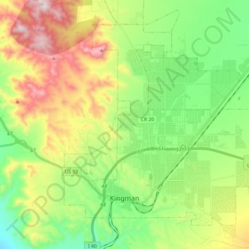
Name: Topografische Karte Kingman, Höhe, Relief.
Ort: Kingman, Mohave County, Arizona, United States (35.17405 -114.09481 35.28733 -113.92299)
Durchschnittliche Höhe: 1.131 m
Minimale Höhe: 827 m
Maximale Höhe: 1.648 m
Lt. Edward Fitzgerald Beale, a U.S. Navy officer in the service of the Army Corps of Topographical Engineers, was ordered by the U.S. War Department to build a federal wagon road across the 35th parallel. His secondary orders were to test the feasibility of the use of camels as pack animals in the Southwestern desert. Beale traveled through the present-day Kingman in 1857 surveying the road and in 1859 to build the road. Beale's Wagon Road became part of U.S. Route 66 and later Interstate 40. Remnants of the wagon road can still be seen in White Cliffs Canyon in Kingman.
Andere topografische Karten
Klicken Sie auf eine Karte, um ihre Topografie, ihre Höhe und ihr Relief anzuzeigen.
Centennial Park
United States > Arizona > Mohave County
Centennial Park, Mohave County, Arizona, 86021, United States
Durchschnittliche Höhe: 1.504 m
Topock
United States > Arizona > Mohave County > Topock
Topock, Mohave County, Arizona, United States
Durchschnittliche Höhe: 180 m
Bullhead City
United States > Arizona > Mohave County > Bullhead City
Bullhead City, Mohave County, Arizona, 89029, United States
Durchschnittliche Höhe: 571 m
Lake Havasu City
United States > Arizona > Mohave County
Lake Havasu City, Mohave County, Arizona, United States
Durchschnittliche Höhe: 279 m