
Topografische Karte Cedarville
Interaktive Karte
Klicken Sie auf die Karte, um die Höhe anzuzeigen.
Über diese Karte
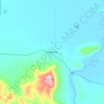
Name: Topografische Karte Cedarville, Höhe, Relief.
Durchschnittliche Höhe: 1.495 m
Minimale Höhe: 1.428 m
Maximale Höhe: 1.932 m
Andere topografische Karten
Klicken Sie auf eine Karte, um ihre Topografie, ihre Höhe und ihr Relief anzuzeigen.
Maluti
South Africa > Eastern Cape > Alfred Nzo District Municipality > Matatiele Local Municipality
Maluti, Matatiele Local Municipality, Alfred Nzo District Municipality, Eastern Cape, South Africa
Durchschnittliche Höhe: 1.487 m
Matatiele
South Africa > Eastern Cape > Alfred Nzo District Municipality > Matatiele Local Municipality
Matatiele, Matatiele Local Municipality, Alfred Nzo District Municipality, Eastern Cape, 4470, South Africa
Durchschnittliche Höhe: 1.603 m
Cedarberg
South Africa > Eastern Cape > Alfred Nzo District Municipality > Matatiele Local Municipality
Cedarberg, Matatiele Local Municipality, Alfred Nzo District Municipality, Eastern Cape, South Africa
Durchschnittliche Höhe: 1.634 m