
Topografische Karte Calverton
Interaktive Karte
Klicken Sie auf die Karte, um die Höhe anzuzeigen.
Über diese Karte
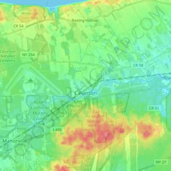
Name: Topografische Karte Calverton, Höhe, Relief.
Durchschnittliche Höhe: 26 m
Minimale Höhe: -6 m
Maximale Höhe: 84 m
Andere topografische Karten
Klicken Sie auf eine Karte, um ihre Topografie, ihre Höhe und ihr Relief anzuzeigen.
Wainscott
États-Unis d'Amérique > New York > Suffolk County > Town of East Hampton
Wainscott, Town of East Hampton, Suffolk County, New York, 11975, États-Unis d'Amérique
Durchschnittliche Höhe: 13 m
Amagansett
États-Unis d'Amérique > New York > Suffolk County
Amagansett, Town of East Hampton, Suffolk County, New York, 11930, États-Unis d'Amérique
Durchschnittliche Höhe: 10 m
Cold Spring Harbor
États-Unis d'Amérique > New York > Suffolk County > Town of Huntington
Cold Spring Harbor, Town of Huntington, Suffolk County, New York, 11724, États-Unis d'Amérique
Durchschnittliche Höhe: 46 m
Mastic
États-Unis d'Amérique > New York > Suffolk County > Mastic
Mastic, Suffolk County, New York, 11950, États-Unis d'Amérique
Durchschnittliche Höhe: 13 m
Riverhead
États-Unis d'Amérique > New York > Suffolk County > Riverhead
Riverhead, Town of Riverhead, Suffolk County, New York, 11901, États-Unis d'Amérique
Durchschnittliche Höhe: 15 m
Riverhead
États-Unis d'Amérique > New York > Suffolk County
Riverhead, Town of Riverhead, Suffolk County, New York, États-Unis d'Amérique
Durchschnittliche Höhe: 13 m