
Topografische Karte Tallahassee
Interaktive Karte
Klicken Sie auf die Karte, um die Höhe anzuzeigen.
Über diese Karte
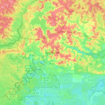
Name: Topografische Karte Tallahassee, Höhe, Relief.
Ort: Tallahassee, Leon County, Florida, 32399-1300, United States (30.27808 -84.44093 30.59808 -84.12093)
Durchschnittliche Höhe: 32 m
Minimale Höhe: 2 m
Maximale Höhe: 83 m
Tallahassee's terrain is hilly by Florida standards, being at the southern end of the Red Hills Region, just above the Cody Scarp. The elevation varies from near sea level to just over 200 feet (61 m), with the state capitol on one of the highest hills in the city. The city includes two large lake basins, Lake Jackson and Lake Lafayette, and borders the northern end of the Apalachicola National Forest.
Andere topografische Karten
Klicken Sie auf eine Karte, um ihre Topografie, ihre Höhe und ihr Relief anzuzeigen.
Saint Peter
United States > Florida > Leon County > Tallahassee
Saint Peter, Tallahassee, Leon County, Florida, 32308, United States
Durchschnittliche Höhe: 49 m
Cascades Park
United States > Florida > Leon County > Tallahassee
Cascades Park, Tallahassee, Leon County, Florida, 32301, United States
Durchschnittliche Höhe: 49 m
Four Points
United States > Florida > Leon County > Tallahassee
Four Points, Tallahassee, Leon County, Florida, 32313, United States
Durchschnittliche Höhe: 24 m
Henrietta
United States > Florida > Leon County > Tallahassee > Henrietta
Henrietta, Tallahassee, Leon County, Florida, 32313, United States
Durchschnittliche Höhe: 20 m