
Topografische Karte Worcester County
Interaktive Karte
Klicken Sie auf die Karte, um die Höhe anzuzeigen.
Über diese Karte
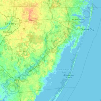
Name: Topografische Karte Worcester County, Höhe, Relief.
Ort: Worcester County, Maryland, United States (37.99428 -75.66177 38.45204 -74.98520)
Durchschnittliche Höhe: 6 m
Minimale Höhe: -3 m
Maximale Höhe: 28 m
The terrain is mostly level and coastal. The lowest elevation is sea level along the Atlantic Ocean and the highest elevation is 49 ft (15 m) in the northwestern part of the county along State Route 12 just south of the Wicomico County line.
Andere topografische Karten
Klicken Sie auf eine Karte, um ihre Topografie, ihre Höhe und ihr Relief anzuzeigen.
West Ocean City
United States > Maryland > Worcester County > West Ocean City
West Ocean City, Worcester County, Maryland, United States
Durchschnittliche Höhe: 2 m
Ocean City
United States > Maryland > Worcester County
Ocean City, Worcester County, Maryland, United States
Durchschnittliche Höhe: 1 m
Stockton
United States > Maryland > Worcester County > Stockton
Stockton, Worcester County, Maryland, United States
Durchschnittliche Höhe: 8 m
Snow Hill
United States > Maryland > Worcester County
Snow Hill, Worcester County, Maryland, United States
Durchschnittliche Höhe: 7 m
Ocean Pines
United States > Maryland > Worcester County
Ocean Pines, Worcester County, Maryland, United States
Durchschnittliche Höhe: 3 m
Assateague Island National Seashore
United States > Maryland > Worcester County > West Ocean City
Assateague Island National Seashore, West Ocean City, Worcester County, Maryland, United States
Durchschnittliche Höhe: 2 m
Newark
United States > Maryland > Worcester County > Newark
Newark, Worcester County, Maryland, United States
Durchschnittliche Höhe: 10 m