
Topografische Karte Sunnyvale
Interaktive Karte
Klicken Sie auf die Karte, um die Höhe anzuzeigen.
Über diese Karte
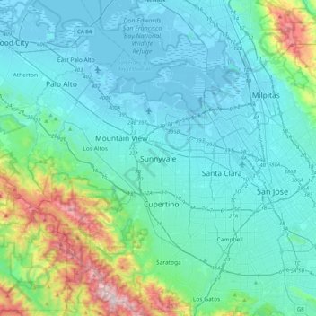
Name: Topografische Karte Sunnyvale, Höhe, Relief.
Durchschnittliche Höhe: 150 m
Minimale Höhe: -6 m
Maximale Höhe: 980 m
According to the United States Census Bureau, the city has a total area of 22.7 sq mi (58.8 km2), of which, 22.0 sq mi (56.9 km2) of it is land and 0.69 sq mi (1.8 km2) of it (3.09%) is water. Its elevation is 130 feet above sea level.