
Spenden
Rüste dich für dein nächstes Abenteuer:
Als Amazon-Partner verdient diese Website an qualifizierten Käufen, ohne zusätzliche Kosten für Sie.
Topografische Karte Thiruvalla
Klicken Sie auf die Karte, um die Höhe anzuzeigen.
Spenden
Rüste dich für dein nächstes Abenteuer:
Als Amazon-Partner verdient diese Website an qualifizierten Käufen, ohne zusätzliche Kosten für Sie.
Thiruvalla
Thiruvalla lies at an altitude of 9 meters above sea level on the basin of the Pamba and Manimala rivers. Thiruvalla is dotted with several natural canal streams (called "thodu" in Malayalam) like Chanthathodu, Manippuzha, Mullelithodu, and several others. The city area has riverine alluvial soil, and eastern parts have a laterite loam kind of soil classified under "Southern Midlands" agro-ecological zone, while the western suburbs like Niranam have a more sandy type of soil that resembles beaches. (Kuttanad agro-ecological zone)[7] The reason for this is believed to be the older status of Niranam as a port, before reclamation of Kuttanad from sea occurred. The Upper Kuttanad region in Thiruvalla has the "Karappadam" type of soil, which is clay loam in texture, has high organic matter, and is situated in areas about 1–2 m above sea level.[7]
Spenden
Rüste dich für dein nächstes Abenteuer:
Als Amazon-Partner verdient diese Website an qualifizierten Käufen, ohne zusätzliche Kosten für Sie.
Über diese Karte
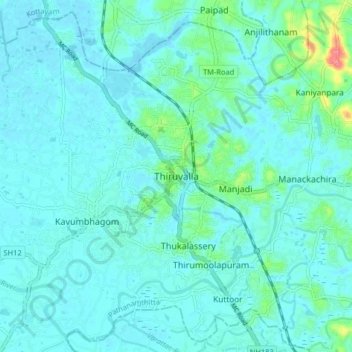
Name: Topografische Karte Thiruvalla, Höhe, Relief.
Ort: Thiruvalla, Pathanamthitta, Kerala, 689111, India (9.34674 76.53627 9.42674 76.61627)
Durchschnittliche Höhe: 10 m
Minimale Höhe: -1 m
Maximale Höhe: 74 m
Spenden
Rüste dich für dein nächstes Abenteuer:
Als Amazon-Partner verdient diese Website an qualifizierten Käufen, ohne zusätzliche Kosten für Sie.
Andere topografische Karten
Klicken Sie auf eine Karte, um ihre Topografie, ihre Höhe und ihr Relief anzuzeigen.