
Topografische Karte Belgorod
Interaktive Karte
Klicken Sie auf die Karte, um die Höhe anzuzeigen.
Über diese Karte
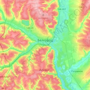
Name: Topografische Karte Belgorod, Höhe, Relief.
Durchschnittliche Höhe: 163 m
Minimale Höhe: 107 m
Maximale Höhe: 227 m
There were several attacks and incidents reported in Belgorod following the start of the Russian invasion of Ukraine in 2022, during which Belgorod was an important logistics centre for Russian armies. Notably, on 1 April 2022 two Ukrainian Mi-24 performed a night raid and set fire to a fuel depot in Belgorod, in a low-altitude airstrike. On 20 April 2023, a Russian Su-34 fighter jet accidentally dropped a bomb on the city, leaving a crater 20 metres (66 ft) across and injuring two people. On 22 April, more than 3,000 people were evacuated from their homes after an undetonated explosive was found; it was not known if the second bomb had come from the same aircraft.
Andere topografische Karten
Klicken Sie auf eine Karte, um ihre Topografie, ihre Höhe und ihr Relief anzuzeigen.
Shchetinovka
Russia > Belgorod Oblast > Belgorodsky District
Shchetinovka, Щетиновское сельское поселение, Belgorodsky District, Belgorod Oblast, Central Federal District, Russia
Durchschnittliche Höhe: 183 m