
Topografische Karte Parc national du Mont-Mégantic
Interaktive Karte
Klicken Sie auf die Karte, um die Höhe anzuzeigen.
Über diese Karte
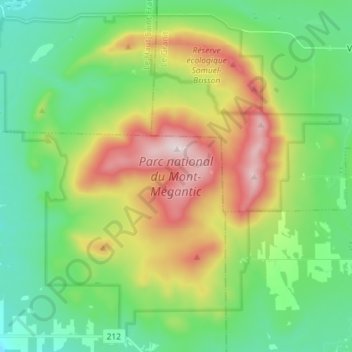
Name: Topografische Karte Parc national du Mont-Mégantic, Höhe, Relief.
Durchschnittliche Höhe: 624 m
Minimale Höhe: 383 m
Maximale Höhe: 1.104 m
Andere topografische Karten
Klicken Sie auf eine Karte, um ihre Topografie, ihre Höhe und ihr Relief anzuzeigen.
Montagne Noire
Montagne Noire, La Patrie, Le Haut-Saint-François, Estrie, Québec, Canada
Durchschnittliche Höhe: 642 m
Mont Notre-Dame
Mont Notre-Dame, La Patrie, Le Haut-Saint-François, Estrie, Québec, Canada
Durchschnittliche Höhe: 742 m