
Topografische Karte Osorno
Interaktive Karte
Klicken Sie auf die Karte, um die Höhe anzuzeigen.
Über diese Karte
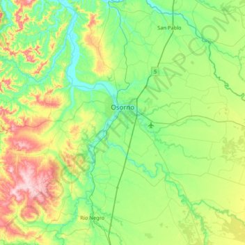
Name: Topografische Karte Osorno, Höhe, Relief.
Ort: Osorno, Provincia de Osorno, Los Lagos Region, Chile (-40.78834 -73.41798 -40.41942 -72.76827)
Durchschnittliche Höhe: 105 m
Minimale Höhe: 0 m
Maximale Höhe: 393 m
Osorno's proximity to the Cardenal Antonio Samoré Pass makes it a key place the national economy. The mountain pass connects Osorno to the Argentine city of Bariloche, and is one of primary arteries that ties the two countries' southern regions together. The pass is particularly important due to the fact that it crosses the Andes mountains at very low altitude, allowing it to remain open even when other passes are blocked by snow.