Geolokalisieren

Topografische Karte Wharncliffe Side

Klicken Sie auf die Karte, um die Höhe anzuzeigen.

Wharncliffe Side

Wharcliffe Side is located on the west bank of the River Don, approximately six miles (9.7 km) northwest of Sheffield city centre, and one mile (1.6 km) northwest of Oughtibridge, south of the confluence of the Ewden beck and the River Don. The village is at an elevation of 435 feet (133 m) and the A6102 road passes through the village.

Wikipedia (CC-BY-SA 3.0)

Über diese Karte

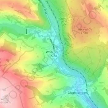
Name: Topografische Karte Wharncliffe Side, Höhe, Relief.

Ort: Wharncliffe Side, Sheffield, South Yorkshire, England, S35 0EZ, United Kingdom (53.42902 -1.57231 53.46902 -1.53231)

Durchschnittliche Höhe: 219 m

Minimale Höhe: 84 m

Maximale Höhe: 396 m

Andere topografische Karten

Klicken Sie auf eine Karte, um ihre Topografie, ihre Höhe und ihr Relief anzuzeigen.

Parkwood Springs

United Kingdom > England > Sheffield

Durchschnittliche Höhe: 94 m

Crookes and Crosspool

United Kingdom > England > Sheffield

Durchschnittliche Höhe: 182 m

River Loxley

United Kingdom > England > Sheffield > Dungworth

Durchschnittliche Höhe: 165 m

Grenoside

United Kingdom > England > Sheffield > Whitley

Durchschnittliche Höhe: 121 m

River Sheaf

United Kingdom > England > Sheffield

Durchschnittliche Höhe: 169 m

Ecclesfield

United Kingdom > England > Sheffield > Whitley

Durchschnittliche Höhe: 217 m

Crookes Valley Park

United Kingdom > England > Sheffield

Durchschnittliche Höhe: 125 m

Endcliffe Park

United Kingdom > England > Sheffield

Durchschnittliche Höhe: 161 m

River Sheaf

United Kingdom > England > Sheffield

Durchschnittliche Höhe: 159 m

Millhouses Park

United Kingdom > England > Sheffield

Durchschnittliche Höhe: 144 m

Stocksbridge

United Kingdom > England > Sheffield > Deepcar

Durchschnittliche Höhe: 235 m

Graves Park

United Kingdom > England > Sheffield

Durchschnittliche Höhe: 174 m

Walkley

United Kingdom > England > Sheffield

Durchschnittliche Höhe: 118 m

Don Valley Bowl

United Kingdom > England > Sheffield

Durchschnittliche Höhe: 54 m

Endcliffe Wood

United Kingdom > England > Sheffield

Durchschnittliche Höhe: 159 m

Meersbrook Park

United Kingdom > England > Sheffield

Durchschnittliche Höhe: 123 m

Matilda Street Pocket Park

United Kingdom > England > Sheffield

Durchschnittliche Höhe: 86 m

Bushey Wood

United Kingdom > England > Sheffield

Durchschnittliche Höhe: 177 m

River Rivelin

United Kingdom > England > Sheffield

Durchschnittliche Höhe: 202 m

Bradfield

United Kingdom > England > Sheffield

Durchschnittliche Höhe: 286 m

Ponderosa

United Kingdom > England > Sheffield

Durchschnittliche Höhe: 113 m

Concord Park

United Kingdom > England > Sheffield

Durchschnittliche Höhe: 91 m

Norfolk Heritage Park

United Kingdom > England > Sheffield

Durchschnittliche Höhe: 125 m

Ecclesfield

United Kingdom > England > Sheffield > Whitley

Ecclesfield lies in the north of Sheffield, about 4 miles (7 km) north of the city centre. The suburb of Ecclesfield is in the south-east of the civil parish with the suburbs Chapeltown and High Green to the north, and Grenoside to the west. Its altitude is 60 metres (200 ft) to 120 metres (390 ft) above mean…

Durchschnittliche Höhe: 128 m

Hesley Wood

United Kingdom > England > Sheffield > Chapeltown

Durchschnittliche Höhe: 110 m

Devonshire Green

United Kingdom > England > Sheffield

Durchschnittliche Höhe: 90 m

Kelham Island

United Kingdom > England > Sheffield

Durchschnittliche Höhe: 79 m

Bingham Park

United Kingdom > England > Sheffield

Durchschnittliche Höhe: 189 m

Woodthorpe Park

United Kingdom > England > Sheffield

Durchschnittliche Höhe: 134 m

Ecclesfield

United Kingdom > England > Sheffield > Whitley

Ecclesfield lies in the north of Sheffield, about 4 miles (7 km) north of the city centre. The suburb of Ecclesfield is in the south-east of the civil parish with the suburbs Chapeltown and High Green to the north, and Grenoside to the west. Its altitude is 60 metres (200 ft) to 120 metres (390 ft) above mean…

Durchschnittliche Höhe: 128 m

Rüste dich für dein nächstes Abenteuer:

🛖Hüttenschlafsack Baumwolle - Vorgeschrieben für Übernachtungen auf Alpenvereinshütten
🔥Sturmfeste Streichhölzer - Sicheres Feuer entfachen auch bei Wind und Wetter
💧Trinkflaschen - Wiederverwendbare Flaschen für unterwegs
🧯Notfallausrüstung - Sicher vorbereitet in der Natur
👟Trailrunning Schuhe - Leichte Alternative zu Wanderschuhen für schnelles Gelände

Als Amazon-Partner verdient diese Website an qualifizierten Käufen, ohne zusätzliche Kosten für Sie.