Geolokalisieren

Topografische Karte Star Valley

Klicken Sie auf die Karte, um die Höhe anzuzeigen.

Star Valley

According to the United States Census Bureau, the town has a total area of 36.1 square miles (93.6 km2), of which 0.01 square miles (0.02 km2), or 0.03%, is water. Star Valley sits at an elevation of 4,650 feet (1,420 m) and takes its name from the valley in which it is located, formed by Houston Creek, which descends to the south through Tonto National Forest to Tonto Creek, a tributary of the Salt River. The town was incorporated as the Town of Diamond Star, but changed its name to Star Valley in 2006.

Wikipedia (CC-BY-SA 3.0)

👉 Easily get elevation data in JSON, GeoTIFF and KML formats using Elevation API
Vielen Dank für die Unterstützung dieser Website ❤️
Spenden

Über diese Karte

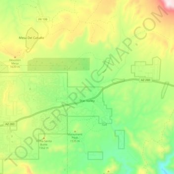
Name: Topografische Karte Star Valley, Höhe, Relief.

Ort: Star Valley, Gila County, Arizona, United States (34.21713 -111.27992 34.30436 -111.20321)

Durchschnittliche Höhe: 1.509 m

Minimale Höhe: 1.221 m

Maximale Höhe: 1.933 m

Andere topografische Karten

Klicken Sie auf eine Karte, um ihre Topografie, ihre Höhe und ihr Relief anzuzeigen.

Hayden

United States > Arizona > Gila County

Durchschnittliche Höhe: 628 m

Rye

United States > Arizona > Gila County

Durchschnittliche Höhe: 1.008 m

Ponderosa Spring Subdivision

United States > Arizona > Gila County

Durchschnittliche Höhe: 2.043 m

Hunter Creek

United States > Arizona > Gila County

Durchschnittliche Höhe: 1.864 m

Hardscrabble Mesa

United States > Arizona > Gila County

Durchschnittliche Höhe: 1.770 m

Christopher Creek

United States > Arizona > Gila County

Durchschnittliche Höhe: 1.851 m

Globe

United States > Arizona > Gila County > Globe

Globe has a semi-arid climate, characterized by hot summers and moderate to warm winters. Globe's arid climate is somewhat tempered by its elevation, however, leading to slightly cooler temperatures and slightly more precipitation than Phoenix or Yuma.

Durchschnittliche Höhe: 1.151 m

Geronimo Estates

United States > Arizona > Gila County

Durchschnittliche Höhe: 1.654 m

Strawberry

United States > Arizona > Gila County

Durchschnittliche Höhe: 1.889 m

Gisela

United States > Arizona > Gila County

Durchschnittliche Höhe: 957 m

Theodore Roosevelt Lake

United States > Arizona > Gila County

Durchschnittliche Höhe: 906 m

Punkin Center

United States > Arizona > Gila County

Durchschnittliche Höhe: 742 m

Tonto National Monument

United States > Arizona > Gila County

Durchschnittliche Höhe: 859 m

Jakes Corner

United States > Arizona > Gila County

Durchschnittliche Höhe: 916 m

See Canyon Summer Homes

United States > Arizona > Gila County

Durchschnittliche Höhe: 1.920 m

Polles Mesa

United States > Arizona > Gila County

Durchschnittliche Höhe: 1.280 m

Copper Hill

United States > Arizona > Gila County

Durchschnittliche Höhe: 1.260 m

Rüste dich für dein nächstes Abenteuer:

🧢Outdoor Mützen - Wärmeisolierung für Kopf und Ohren
🧗Karabiner - Zuverlässige Karabiner für Sicherung und Transport
🍳Outdoor Kochset - Leichtes Geschirr aus Aluminium oder Titan
🥾Wanderschuhe für Damen - Leichte und stabile Wanderschuhe für Berg- und Naturwanderungen
🔨Heringe für harten Boden - Sicherer Halt für das Zelt auch in felsigem Alpingelände

Als Amazon-Partner verdient diese Website an qualifizierten Käufen, ohne zusätzliche Kosten für Sie.