
Topografische Karte Woolwine
Interaktive Karte
Klicken Sie auf die Karte, um die Höhe anzuzeigen.
Über diese Karte
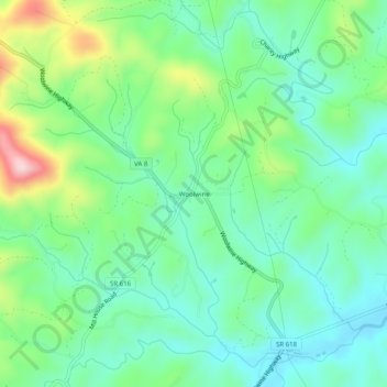
Name: Topografische Karte Woolwine, Höhe, Relief.
Ort: Woolwine, Patrick County, Virginia, 24185, United States (36.76986 -80.29728 36.80986 -80.25728)
Durchschnittliche Höhe: 454 m
Minimale Höhe: 376 m
Maximale Höhe: 647 m
Andere topografische Karten
Klicken Sie auf eine Karte, um ihre Topografie, ihre Höhe und ihr Relief anzuzeigen.
Poor Mountain
United States > Virginia > Patrick County
Poor Mountain, Patrick County, Virginia, United States
Durchschnittliche Höhe: 373 m
Patrick Springs
United States > Virginia > Patrick County
Patrick Springs, Patrick County, Virginia, 24171, United States
Durchschnittliche Höhe: 389 m
Critz
United States > Virginia > Patrick County
Critz, Patrick County, Virginia, 24082, United States
Durchschnittliche Höhe: 336 m
Claudville
United States > Virginia > Patrick County
Claudville, Patrick County, Virginia, 24076, United States
Durchschnittliche Höhe: 432 m
Groundhog Mountain
United States > Virginia > Patrick County
Groundhog Mountain, Patrick County, Virginia, 24053, United States
Durchschnittliche Höhe: 814 m
Meadows of Dan
United States > Virginia > Patrick County
Meadows of Dan, Patrick County, Virginia, 24120, United States
Durchschnittliche Höhe: 888 m
Stuart
United States > Virginia > Patrick County
Stuart, Patrick County, Virginia, United States
Durchschnittliche Höhe: 411 m
Carters Mill
United States > Virginia > Patrick County > Carters Mill
Carters Mill, Patrick County, Virginia, United States
Durchschnittliche Höhe: 456 m
Buffalo Ridge
United States > Virginia > Patrick County
Buffalo Ridge, Patrick County, Virginia, 24185, United States
Durchschnittliche Höhe: 488 m