
Spenden
Rüste dich für dein nächstes Abenteuer:
Als Amazon-Partner verdient diese Website an qualifizierten Käufen, ohne zusätzliche Kosten für Sie.
Topografische Karte Ashby St. Mary
Klicken Sie auf die Karte, um die Höhe anzuzeigen.
Spenden
Rüste dich für dein nächstes Abenteuer:
Als Amazon-Partner verdient diese Website an qualifizierten Käufen, ohne zusätzliche Kosten für Sie.
Ashby St. Mary
Ashby's topography is, like most of East Anglia, made up of river meadows and flat agricultural landscape. The geology mostly consists of Cainozoic Sedimentary rock, with a layer of boulder clay and sand laid down in the last ice age. Ashby St Mary has slightly acidic loamy and clayey soils with impeded drainage, and low carbon. The cropping of Ashby is reasonably flexible but more suited to autumn sown crops and grassland.
Spenden
Rüste dich für dein nächstes Abenteuer:
Als Amazon-Partner verdient diese Website an qualifizierten Käufen, ohne zusätzliche Kosten für Sie.
Über diese Karte
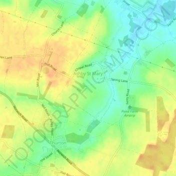
Name: Topografische Karte Ashby St. Mary, Höhe, Relief.
Ort: Ashby St. Mary, South Norfolk, Norfolk, England, United Kingdom (52.55960 1.42062 52.57195 1.45185)
Durchschnittliche Höhe: 20 m
Minimale Höhe: 0 m
Maximale Höhe: 36 m
Spenden
Rüste dich für dein nächstes Abenteuer:
Als Amazon-Partner verdient diese Website an qualifizierten Käufen, ohne zusätzliche Kosten für Sie.
Andere topografische Karten
Klicken Sie auf eine Karte, um ihre Topografie, ihre Höhe und ihr Relief anzuzeigen.
Poringland Wood
United Kingdom > England > Norfolk > South Norfolk > Framingham Earl
Durchschnittliche Höhe: 50 m
Spenden
Rüste dich für dein nächstes Abenteuer:
Als Amazon-Partner verdient diese Website an qualifizierten Käufen, ohne zusätzliche Kosten für Sie.
Fundenhall
United Kingdom > England > Norfolk > South Norfolk > Ashwellthorpe and Fundenhall
Durchschnittliche Höhe: 50 m
Spenden
Rüste dich für dein nächstes Abenteuer:
Als Amazon-Partner verdient diese Website an qualifizierten Käufen, ohne zusätzliche Kosten für Sie.
Kirby Row
United Kingdom > England > Norfolk > South Norfolk > Kirby Cane
Durchschnittliche Höhe: 16 m
Thurlton Links
United Kingdom > England > Norfolk > South Norfolk > Thurlton
Durchschnittliche Höhe: 14 m
Spenden
Rüste dich für dein nächstes Abenteuer:
Als Amazon-Partner verdient diese Website an qualifizierten Käufen, ohne zusätzliche Kosten für Sie.
Highoak
United Kingdom > England > Norfolk > South Norfolk > Morley St Botolph
Durchschnittliche Höhe: 47 m
Spenden
Rüste dich für dein nächstes Abenteuer:
Als Amazon-Partner verdient diese Website an qualifizierten Käufen, ohne zusätzliche Kosten für Sie.
Beckhithe
United Kingdom > England > Norfolk > South Norfolk > Little Melton > Beckhithe
Durchschnittliche Höhe: 37 m
Spenden
Rüste dich für dein nächstes Abenteuer:
Als Amazon-Partner verdient diese Website an qualifizierten Käufen, ohne zusätzliche Kosten für Sie.
Tivetshall St Margaret
United Kingdom > England > Norfolk > South Norfolk
Durchschnittliche Höhe: 49 m
Spenden
Rüste dich für dein nächstes Abenteuer:
Als Amazon-Partner verdient diese Website an qualifizierten Käufen, ohne zusätzliche Kosten für Sie.
Deopham Green
United Kingdom > England > Norfolk > South Norfolk > Deopham
Durchschnittliche Höhe: 51 m
Spenden
Rüste dich für dein nächstes Abenteuer:
Als Amazon-Partner verdient diese Website an qualifizierten Käufen, ohne zusätzliche Kosten für Sie.