
Topografische Karte Texas City
Interaktive Karte
Klicken Sie auf die Karte, um die Höhe anzuzeigen.
Texas City
Officially, the elevation of Texas City is 10 feet above sea level, though some areas are even lower. It was naturally vulnerable to flooding by hurricane storm surges and heavy rainstorms.
Über diese Karte
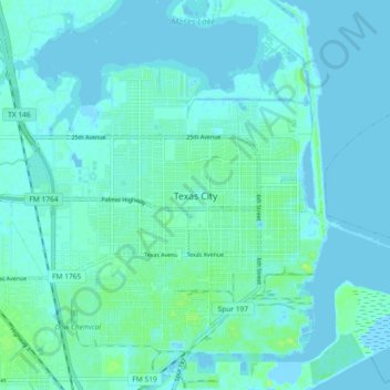
Name: Topografische Karte Texas City, Höhe, Relief.
Ort: Texas City, Galveston County, Texas, 77590, United States (29.35601 -94.95755 29.43601 -94.87755)
Durchschnittliche Höhe: 3 m
Minimale Höhe: -4 m
Maximale Höhe: 14 m