
Topografische Karte Malton
Interaktive Karte
Klicken Sie auf die Karte, um die Höhe anzuzeigen.
Über diese Karte
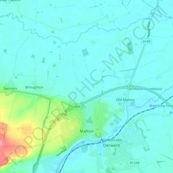
Name: Topografische Karte Malton, Höhe, Relief.
Durchschnittliche Höhe: 28 m
Minimale Höhe: 15 m
Maximale Höhe: 91 m
As with the rest of the British Isles and Yorkshire, Malton possesses a maritime climate with cool summers and mild winters. The nearest Met Office weather station for which records are available is High Mowthorpe, about 6 miles (10 km) east of the town centre. Due to its lower elevation, the town centre is likely to be marginally warmer than High Mowthorpe throughout the year.