
Topografische Karte Town of Otego
Interaktive Karte
Klicken Sie auf die Karte, um die Höhe anzuzeigen.
Über diese Karte
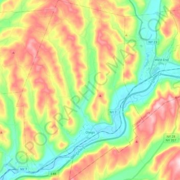
Name: Topografische Karte Town of Otego, Höhe, Relief.
Ort: Town of Otego, Otsego County, New York, 13825, United States (42.35902 -75.25359 42.50289 -75.11528)
Durchschnittliche Höhe: 453 m
Minimale Höhe: 314 m
Maximale Höhe: 649 m
Andere topografische Karten
Klicken Sie auf eine Karte, um ihre Topografie, ihre Höhe und ihr Relief anzuzeigen.
Town of Hartwick
United States > New York > Otsego County
Town of Hartwick, Otsego County, New York, United States
Durchschnittliche Höhe: 489 m
Town of Worcester
United States > New York > Otsego County
Town of Worcester, Otsego County, New York, United States
Durchschnittliche Höhe: 553 m
Town of Maryland
United States > New York > Otsego County
Town of Maryland, Otsego County, New York, 12155, United States
Durchschnittliche Höhe: 490 m
Lena
United States > New York > Otsego County > Town of New Lisbon
Lena, Town of New Lisbon, Otsego County, New York, 13810, United States
Durchschnittliche Höhe: 455 m
Village of Cooperstown
United States > New York > Otsego County
Village of Cooperstown, Town of Otsego, Otsego County, New York, United States
Durchschnittliche Höhe: 417 m